
The Gift of South Dakota
Subscriptions to South Dakota Magazine make great gifts!
Subscribe today — 1 year (6 issues) is just $29!
Badlands South: Corner-to-Corner
Nov 1, 2017
 |
| The temple ruins in the Garden of the Gods. |
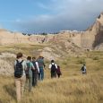
The Badlands has this other unit (actually two) that you might not know about.
The South Unit is not exactly a secret. People from around the world do veer off the famous Badlands Loop road to explore its outer edges. But only a tiny fraction of the total visitors to Badlands National Park visit the South Unit at all, let alone explore its inner reaches on foot.
The South Unit and its even more unknown and inaccessible cousin — the Palmer Unit — have no paved roads and no hiking trails. Eventually that may change. Badlands National Park and the Oglala Sioux Tribe jointly manage the unit. For years, there have been talks about potentially developing Badlands South as the first tribal national park. For now, other than a few ranchers and their cattle (yes, on a national park, it’s complicated) the unit remains very lightly traveled.
Despite the lack of dedicated hiking trails though, you can explore the hidden grandeur of the South Unit on foot. But, for those who are interested in doing so, there's very little information out there. So we hiked corner to corner across the South Unit to demonstrate that it can be done.
The route we took is just one of many possibilities. There’s only one place to park a vehicle though (other than on the shoulder of a country road, which may not be safe or even legal) — the White River Visitor Center at the southeast corner of the unit. We parked there and caught a ride to the northwest corner of the unit, near the Red Shirt community.
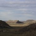
 |
| Coffin Butte. |
We brought the basic camping supplies: 4 liters of water, a map and an iPhone 6S with the Gaia GPS app. With an annual membership you get access to National Geographic Trails Illustrated maps of public lands. And since you don't need cell service for geotracking to work, you can keep your phone on airplane mode, use it as a GPS and use very little battery. We packed a mobile charger but didn't really need it.
South Unit Ranger Richard Sherman had previously guided us to a freshwater spring about 14 or 15 miles, by foot, from the start. We marked the coordinates on Gaia and made it, roughly, our halfway point so we wouldn’t have to carry as much water.
Before the northbound BIA 42 crosses the Cheyenne River, there’s a dirt road on the right. This is where we started. The Trails Illustrated map showed another right ahead on a south/southeast bound two-track ranch road. Here's the thing about the "no trails" deal in the South Unit. The "roads" inside the park are basically trails. In fact, they're no different than some of the ATV-maintained hiking trails at Wind Cave National Park and other prairie parks, except that there are no blazes, and there are lots of forks, and occasionally a two track becomes a single cattle trail or no trail at all. When we wanted to stay on "the road" for a while, but weren't sure which fork to take, Gaia (which isn’t paying us) never failed.
About a quarter mile in, this second road climbed atop a hill yielding spectacular 360-degree views of the Badlands and a lucky group of free-range mustangs. This road parallels a bend in the Cheyenne before descending south/southeast into Battle Creek Canyon. You can follow this narrow, scenic canyon nestled between pink and white cliffs for about a dozen miles before you run into the edge of Cuny Table.
Along the trail, the yellow blossoms of rubber rabbitbrush were swarmed with throngs of butterflies. The breeze schlepped in aroma of sage and prairie dog song filled the air. (And less exotic sounds.)
 |
| Butterflies swarm on rubber rabbitbrush. |
South Unit administration is a tangle of tribal and NPS interests, complicated by the Korean war-era seizure of Lakota ranching lands for a former bombing range (locals say there’s still unexploded ordinance out there). As a result, bringing the South Unit under the auspices of Badlands National Park required granting grazing rights to ranchers. So out here, you share the trail with cattle, and occasionally cross a fence or two. As we walked through the canyon, a skittish herd not very accustomed to strangers stayed always a little ahead of us. If you’re keen on avoiding a bovine escort, you might stay out of Battle Creek Canyon, because there’s nowhere for them to go but just up ahead, and then just up ahead again.
Cows or no, the canyon does offer a chance to appreciate the geologic wonders of the Badlands up close and in relative solitude. There are gangly chimney spires, faceless sand-mannequins with prickly pear toupees and fluffy pink dunes. Battle Creek itself carves out canyons-within-the-canyon where tight coils of canyon wall form hidden rock closets that reemerge into the open around a bend. The wind braids itself through old bones in cottonwood groves. No engines hum. Out here, it’s just you and the Badlands (and the cows). No paved roads, no people.
Eventually the road/trail runs out in a scrubby flume at the edge of Cuny Table. The spring we had marked is one of several here that burrows under and over ground down the steep ravine, and then emerges to feed a system of small streams. We figured any stream would lead to a relatively easy route to the tabletop, but that didn’t happen. And here’s as good a place as any to insert an obligatory word of caution. Hiking off-trail across the South Unit is not without its hazards, and making your own way up and down plateaus like Cuny Table is one of them. If you’re trailblazing to the top, be aware that hand and footholds are sometimes less solid then they look. Hold onto a cedar or some rabbitbrush branches if you can.
At the top, a light rain was falling and we quickly found the spring, aided by GPS of course. This particular spring has been capped and fills a cattle trough, the overflow spilling into subterranean streams. The taste is cool, mineral-rich and refreshing. A microbrew made from Cuny Table spring water — in bottles with a nice bison-on-the-Badlands label — would probably fly out of the coolers at bars in Wall and Interior.
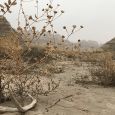
 |
| Fog Creek marsh. |
We’d walked about 15 miles of rocky terrain and the sun was sinking. A herd hugged Cuny’s northern rim and we didn’t want to fall asleep to cow song, so we trekked west across a two-track through a sunflower field, across a small peninsula of non-park land, in search of a spot to set up camp. Crossing back onto park land, we found a good flat spot to pitch a tent. After a long day in the canyon, the view on the plateau can feel like a let down. Then sun meets horizon and golden hour scatters pixie dust over the prairie as the animals come out to forage and hunt. The silky hairs of velvet mullein shimmer and stand on end like tiny antennae soaking up sun butter. At dusk you can sit and emulate those amber waves. This is a wealthy place. And that Cuny Table spring water tastes like champagne when you’re thirsty.
After sunset, a radio tower blinked. We imagined conspiracy theories and relationship advice traveling through space in indecipherable frequencies. Our cheap tent from Cabela's flapped incessantly in the breeze.
In the pre-dawn light, a coyote ambled toward the rising sun and a system of beautiful, rolling sand hills that billow up from atop the plateau. On the east side of the sand hills, we looked for a pass from Cuny Table to the floor at the foot of Coffin Butte.
Richard Sherman had warned about getting bogged down in the bottomlands around Fog Creek, but looking for a way down, it seemed like the ticket. The creek pass became a thick, almost impassable cedar thicket, that seemed to wind forever through brush that we sometimes had to crawl through, but gradually it wound its way down off Cuny Table.
Here was the route’s grand culmination, emerging onto a coliseum floor in the shadow of Coffin Butte, surrounded by monuments as odd in their own natural way as the giant prairie dog at the Ranch Store or Wayne Porter’s bullhead off I-90. A pyramid formation juts sunward and stops short its ascent, topped with an emerald green stage as planate as an office desk.
 |
| The view from atop Cuny Table. |
This is where the whole operation begins to make perfect sense. Sure, you’ve blazed 30 miles of trail across a rocky, boot-busting, unsigned wilderness, alongside a skittish herd of beeves no less. But now you’re here. Each monolith or pinnacle or hoodoo in this enchanted garden is a totem to geologic eras that stretch back for eons. This is church. The journey here should be challenging. To show up clean and rested as if stepping off an airport conveyor would miss the point. A ragged nerve, a sleepless mind, is a point of union with the rock, a correspondence with the two and four-legged travelers that came before you. Maybe this is a place where signs could only ever misdirect.
Fog Creek crochets its way through this Garden of the. Wide stretches of reeds and cattails line its banks, a marshland winding through a rocky desert. One thing you learn exploring the South Unit is that the Badlands contain ecosystems — swampy wetlands, thick riparian forests — beyond the ones you see in your Facebook feed. Avoiding the Fog Creek marsh as it snakes through the Garden is nearly impossible without cutting straight north, adding another dozen or so miles to the journey.
After passing Coffin Butte, the next and final landmark on the way back to the White River Visitor Center is Cedar Butte, a mesa aptly named for the cedar canopy you can spot from miles away, and a favorite hangout for bighorn sheep. In the final stretch, beneath Cedar Butte, our journey paralleled BIA 2 so closely that eventually we just walked down the road. A single car passed.
At a curve in the road we cut southeast through the park again, and found an easy White River crossing, then crossed a final stretch of prairie before reaching the visitor center, where we found Richard Sherman. He said we were crazy, but also that he was interested in a longer, crazier route. The South Unit holds as many possibilities as there are hikers with an itch to explore. We can say we’ve walked from one corner of the South Unit to the other, but we haven’t surveyed the scene from the top of Stronghold Table, or Galigo or Plenty Star, or traversed the Cactus Flats or navigated Cottonwood Pass. Our route covered about 30 miles in two days, and that was enough, for now. But there’s something out there in that unsigned, other Badlands that will bring us back.
Michael Zimny is the social media engagement specialist for South Dakota Public Broadcasting in Vermillion. He blogs for SDPB and contributes arts columns to the South Dakota Magazine website.
Comments
I thoroughly enjoyed reading your article as I plan my own hike across the South Unit this upcoming April. Your words and photos have successfully piqued my interest! Many thanks.
- Rodney of Stillwater, OK