The Gift of South Dakota
Subscriptions to South Dakota Magazine make great gifts!
Subscribe today — 1 year (6 issues) is just $29!
Untamed Harding County
Apr 19, 2016
 |
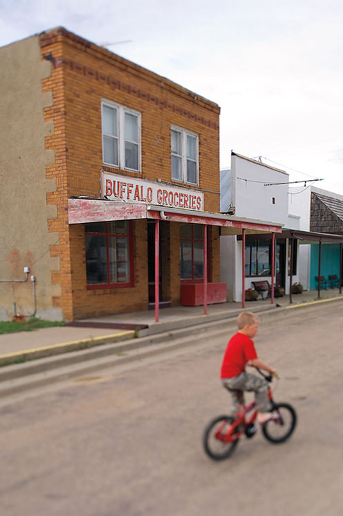
Harding County, in the far northwestern corner of South Dakota, is decidedly rural. Buffalo, the county seat with a population of 330, is the largest town. Camp Crook has 100, and smaller communities like Ralph, Reva, Ludlow, Ladner and Harding might have a few ranch families. The county as a whole is home to 1,255 people, making it the second least populated county in South Dakota. Cattle and sheep outnumber people almost 10 to 1, and the most legendary stories are about a killer wolf with three toes and a rambunctious rodeo bronc that has been memorialized in bronze. Still, Harding County’s unique geography and history have drawn curious travelers and explorers for centuries.
It began even before there was a Harding County. The place was created in 1881 and named for Dr. John A. Harding, a dry goods merchant and postmaster from Deadwood who was also serving as Speaker of the House in the Dakota Territorial Legislature. Harding County merged for a few years with Butte County, its neighbor to the south, then became separate again in 1909.
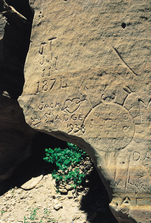
On his gold exploring expedition to the Black Hills in 1874, Gen. George Custer heard stories from a Lakota guide named Goose about unique drawings etched into canyon walls. Goose brought him to the Cave Hills north of present day Buffalo, which boasts several petroglyphs dating back thousands of years.
There are drawings of bison, antelope, a warrior and spear and others even more difficult to discern because of their age and the effects of weathering. A member of the expedition is thought to have carved his initials into a rock wall that also bears the image of a large body shield and weapon. Names and initials of 20th century visitors can be found, too.
 |
| Buffalo is the Harding County seat and features a sculpture of legendary bronc Tipperary in the city park. |
The Cave Hills are part of the Custer National Forest, pockets of which are spread throughout the county. The section farther to the east contains the Slim Buttes, a blend of badlands, pine forest and mesas that runs 40 miles north to south and stretches 20 miles wide. Local ranchers have named most of the peaks and buttes. There are the Seals, the Three Sisters, Doc Hodges Draw, Adam and Eve Butte and Battleship Rock. Highway 79 crosses Slim Buttes to the south and Highway 20 runs west of Reva.
One of the more spectacular features of the Slim Buttes is the Castles, one of South Dakota’s 13 National Natural Landmarks. The Castles are an L-shaped ridge of bluffs that stretch 30 miles across eastern Harding County. The twin white buttes looming south of Highway 20 contain exposed rock dating as far back as the Upper Cretaceous period (100 million to 66 million years old) through the Miocene (23 million to 5 million years old). The Castles also contain a variety of fossils, but collection is prohibited because they lie within the Custer National Forest.
Their name comes from John Finerty, an Irish newspaperman who traveled with Gen. George Crook’s Expedition of 1876. As they passed through the rugged country, Finerty compared the formation to “a series of mammoth Norman castles.” They look particularly medieval in the morning or evening light, when the white stone shines like polished granite.
The area is also historically important. A memorial and three graves just east of the Castles mark the scene of the Battle of Slim Buttes, a fight between a few hundred Indians and 2,000 cavalrymen in September 1876, just three months after the Battle of the Little Bighorn. After that defeat, Captain Anson Mills was ordered to the Black Hills to resupply. His march took him through the Slim Buttes, the site of American Horse’s camp. Troops surrounded the village of 37 lodges and opened fire. American Horse was shot through the abdomen, but refused help from Army surgeons. He died within days. Locals say you can still see scars from the bullets on ancient trees along Deer Draw Pass. Headstones mark the burial site of three cavalry soldiers who died in the conflict. The graves are east of the Castles along Highway 20.
 |
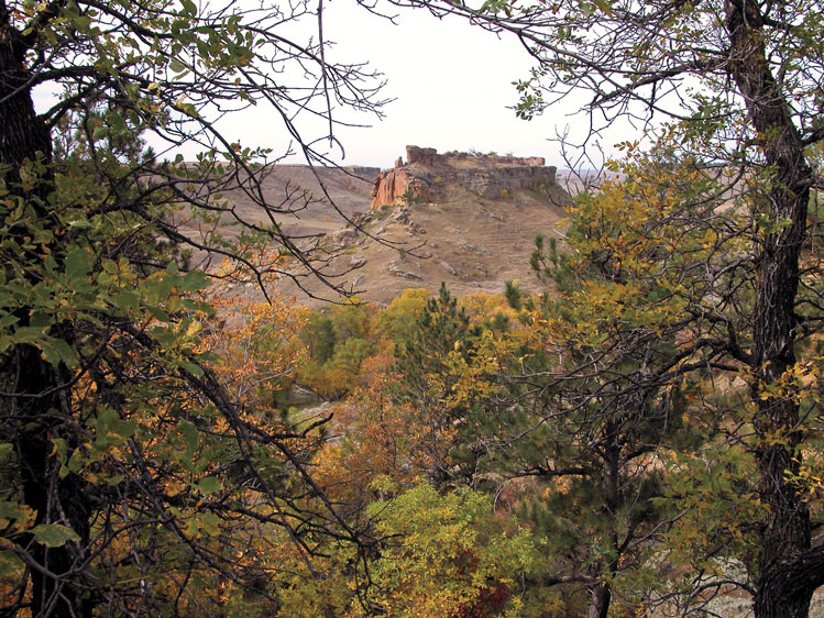
| The Island is a mesa in the Cave Hills that has attracted people for centuries. |
Another gravesite in the Slim Buttes is a reminder of South Dakota’s vicious winters. During the notorious Children’s Blizzard of January 1888, Otis Bye, a scout and trapper, was away from home. His wife ventured outside to save their horses. Her frozen body was found days later, watched over by the family dog. Decades later, neighbors erected a gravestone at the site. Find it by driving east of Buffalo on Highway 20 about 19 miles to North End Road. Take a left and drive a quarter of a mile until you reach an old trail. Hike down the trail to the gravesite.
With its abundance of ranches, it’s no surprise that rodeo has had a strong presence in Harding County. South Dakota’s most famous bucking bronc was was born on a ranch by Long Pines in 1905. He bolted the first time a rider attempted to get on his back, so ranchers deemed him unfit for ranch work. Later they tried him as a rodeo bronc. Ed Marty was the first to try a ride and was immediately thrown clear. “It’s a long, long way to Tipperary!” he said, thus giving the horse his name.
For 15 years, 82 cowboys tried and failed to ride Tipperary. Then came the Belle Fourche Roundup in 1920, where Yakima Canutt became the first — and only — cowboy ever to successfully stay atop Tipperary. Despite his victory, cowboys still debated the merits of the ride because rainfall made the arena muddy. Tipperary slipped to his knees and never gained strong footing.
 |
| Members of Custer's 1874 Black Hills expedition are thought to have scrawled initials into this rock wall in the Cave Hills. It also contains an ancient depiction of a shield. |
Tipperary died during a blizzard in 1932, but people in Buffalo and Harding County never forgot their star athlete. In 1955 they erected a monument in Buffalo’s city park, and in 2009 the town dedicated a half-size statue done by cowboy sculptor Tony Chytka of Belle Fourche. There’s also an exhibit dedicated to Tipperary inside the Buffalo Museum.
A wild contemporary of Tipperary’s was Three Toes, a gray wolf that terrorized ranchers and sheepherders for 13 years, killing at least $50,000 worth of stock. Legendary sheepherder and writer Archie Gilfillan described the carnage. “Other wolves might kill one cow or sheep and eat off that and be satisfied. But Three Toes killed for the sheer love of killing. He would kill on a full stomach as well as when hungry. On one occasion he visited three different ranches in one night, killed many sheep and lambs at each one, but ate only the liver of one lamb.”
His reign of terror began in 1912, which was about the time he sustained the injury that gave him his name. One of his toes was pinched off in a trap, and from that day the tracks he left in the dirt and snow were as distinguishing as a human fingerprint.
It was estimated that 150 men tried at one time or another to capture him, but Three Toes always seemed to have speed, intelligence and luck on his side. By 1925, he was killing at a rate of $1,000 worth of stock a month. The Harding County Commission raised the bounty on him to $500. A federal hunter named Clyde Briggs, an experienced hunter of gray wolves, came to Harding County and set an elaborate network of traps that extended 33 miles around Three Toes’ favorite ranch targets. On July 23, Briggs descended into the Little Missouri River valley and discovered Three Toes caught in the snares of two traps. He was muzzled and loaded into Briggs’ car but died before they reached Buffalo.
Three Toes and Tipperary are long gone, but their legends, the cattle and sheep, the rugged buttes and mesas, the stone johnnies and 1,200 hearty souls remain.
Editor’s Note: This is the 22nd installment in an ongoing series featuring South Dakota’s 66 counties. Click here for previous articles.


Comments
The casey tibbs rodeo center will be honoring tipperary on nov 4th in Ft Pierre
would you have any slide shows or items for a table at this event
also could you post an invitation on your web site thanks
I'm especially interested in the path of the Astroian's, lead by Wilson Price Hunt, who passed thru Harding County in 1811 enroute to the Columbia River.
A sign at the Buffalo historic park say's so. It's the only evidence I've seen so far to even remotely confirm the path they took. They passed over the Slim Buttes into Carter County heading S-W until they hit the Powder River then turned south into Wyoming leaving little clues or evidence of their passing until Union Pass in the Wind River range.
I wrote for the Ekalaka, Mt. museum a description, such as I could produce, of that 1811 passage. Their return trip was well noted and many sites have been confirmed including discovery of the "South Pass" in 1812 as well as along the North Platte River into Nebraska.
My book on the subject started as a historical biography of a fellow named Robert McClellan, a soldier trader, trapper & etc. who made the trip as an Astorian, both ways, afoot. It's called Perilous Paths, the story of Robert McClellan....available on Amazon
My dad was a member of the local Historical Society back in the 60's and 70's and on one occasion both him and I had the pleasure of meeting one of Captain Anson Mills' grandsons who came to visit the Slim Buttes Battle location. It was very interesting to visit with a Grandson of one of participants in this battle which was the US Calvary's first recorded battle victory after Custer's defeat at the Little BIg Horn.