The Gift of South Dakota
Subscriptions to South Dakota Magazine make great gifts!
Subscribe today — 1 year (6 issues) is just $29!
Off Trail in Custer State Park
Sep 5, 2018
Most of the hiking trails in Custer State Park are point-to-point. And while linear excursions are great, some of us are like a cowgirl roping calves: we appreciate a good loop. There are a few designated loop trails in the park but you can also customize your own if you're feeling adventurous and have land-nav skills (or GPS). In the process, you'll glimpse parts of the park few humans ever see.
There are many logging and park roads you can incorporate into your route, though any off-trail trekker should be prepared to follow game trails or trailblaze, so trekking as a team is recommended and snake-proof gaiters wouldn't hurt.
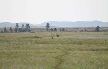
We recently tested this theory with a venture to the Hay Flats area in the southwest corner of the park. The Hay Flats is a high, grassy plane (about 4,200 feet in elevation) surrounded by rocky hilltops, where prairie dogs burrow, raptors and coyotes hunt, elk, deer and antelope browse, and buffalo wallow. It's a secret small grass sea where you can see for miles across a flattish expanse with waves of big bluestem, and close-clipped buffalo grass in the prairie dog towns (just watch out for abandoned burrows).
It's a place to escape humanity. You may wonder, "If I lay in the buffalo wallow until I achieved true buffalo-mindedness, would they adopt me into their herd?"
The answer is probably no. But if that's the zen you're after, those signed-up, mapped-out trails might not get you there. You'll have to dial up your store of navigational knowledge, or tools, to get you to the Hay Flats — and then back to the car if you don't just drop everything and go live off the grid.
Both the Centennial and the Prairie Trail get you close to the Flats. I parked (no fee required) at the Highland Creek parking area, on NPS 5 where the Centennial crosses from Wind Cave National Park into Custer SP.
From there, you can cross the street into the state park, open the gate and be on your way. You'll hike through patches of ponderosa pine forest and open meadow, and through some recent burn areas, though many of the larger trees survived. Just shy of 3 miles in, a logging road crosses the trail right as you reach a gully that joins Flynn Creek a short ways west. (You can see it on a good GPS map. I use Gaia GPS on my iPhone.) A right turn leads to a climb with sweeping views of a half-burned valley to the north. The road peters out a mile in. From there, I followed game trails down a pass into the dog towns of Flynn Creek valley, close to the Prairie Trail. The little creek still coursed with crystal clear water this late August.
From here, another two-track took a northeasterly climb up out of the valley before meeting another that switched back southwest onto the Hay Flats, where three coyotes prowled and an antelope trio browsed. The wind rustled through rusty seed heads of bowing bluestem. Portents of fall mingled in the breeze with phantom winds from seasons past.
From the Hay Flats, some southeasterly trailblazing led to another two-track over some piney hills and back to the junction of the NPS 5 and the Centennial Trail. My route clocked in at 8.6 miles and probably only included about a quarter mile total that were truly off-trail (no two-track, no game trail).
Though the park is crisscrossed by logging and park "roads," once you leave designated hiking trails you can't depend on those to get you where you want to go. (This especially applies to the more mountainous areas). But if you're a seasoned hiker with a little know-how or tech (water and food also help) you can explore parts of the Black Hills the guidebooks don't cover.
Michael Zimny is the social media engagement specialist for South Dakota Public Broadcasting in Vermillion. He blogs for SDPB and contributes arts columns to the South Dakota Magazine website.



Comments
the more subtle areas
when you find yourself alone there
that's the best