Nut trees can flourish in a sliver of South Dakota, but will their growers ever be more than hobbyists?

By John Andrews
Dan DeBuhr was 6 years old in the early 1960s when his grandmother returned from a vacation in Texas with two pecan trees. She planted them in the backyard of her Elk Point home — the same patch of land where DeBuhr lives today — not knowing what to expect. “They told her they couldn’t guarantee that they would make it in South Dakota,” DeBuhr says. “And they would never bear fruit.”
Today, motorists passing by on Interstate 29 can easily spot them because they are the tallest trees in town. In fact, measurements taken last June confirm that they are the two biggest pecan trees in South Dakota, both supplanting a 61-foot pecan in Rapid City.
A severe thunderstorm pelted Elk Point with baseball sized hail early last summer, greatly diminishing the year’s pecan crop. But near the end of most Septembers, DeBuhr wages a daily battle with squirrels to collect the prized nuts. The little critters clearly collect their share, evidenced by the tiny trees that spring up from pecans buried around his yard.
We think of more temperate places when we think of pecans, but they have a history in South Dakota. Pecans — as well as hickory, chestnuts, heartnuts, butternuts, English walnuts and maybe even pine nuts — can indeed grow in certain parts of South Dakota, and experimenters are working to create the best varieties for our environment.
*****
South Dakota is not a robust nut-producing state. Black walnuts are the only nut trees considered native, but John Ball, a professor at South Dakota State University in Brookings, says you can find butternut, American chestnut, English walnut, Manchurian walnut and even pecan, though the growing season is not always long enough to produce nuts. Far southeastern South Dakota, however, is another story.
“It is an unusual part of the state,” says Ball, who is also an SDSU Extension forestry specialist and South Dakota Department of Agriculture and Natural Resources forest health specialist. “We should call it Western Iowa/Northern Nebraska, not South Dakota, and then it would fit. Growing pecans in those states would not be surprising, and southeastern South Dakota is kind of an extension of that. But it’s a rather abrupt line as we move out of there as to where something grows, where something’s a shrub and where something just never makes it at all.”
Our native black walnut provides a good example. “Black walnut is only native to eastern South Dakota, and really the southeast, though there is one population up in Codington County,” Ball says. “But it will even grow in Harding County. I’ve seen some trees out by Union Center and Bison. The difference is the ones down by Yankton and Vermillion can get a couple feet in diameter and 70 feet tall. The ones up in Bison get about 6 inches in diameter and maybe 20 feet tall. So while they can grow there, they grow very slowly. Down in the southeast, you can grow most of the nut trees that can grow out East, though not always as productively and not as quickly. And you have to really work at it. It doesn’t come easily.”
Any discussion of trees and plants and where they might succeed brings to mind the USDA Plant Hardiness Zone Map, the reference that many gardeners consult before planting. The map is based on a region’s annual average extreme minimum temperatures, with lower zone numbers coinciding with colder temperatures. Much of the northern half of South Dakota lies in Zone 4b (-25 degrees Fahrenheit to -20), though some pockets, including Aberdeen, fall in 4a (-30 to -25). The southern half is largely 5a (-20 to -15), with some areas of 5b (-15 to -10) west of Yankton and around the Black Hills, including Rapid City.
But the map may be irrelevant. Ball says the more important factor for nut trees is the number of frost-free days. “I recommend throwing the zone map out when you get to South Dakota,” Ball says. “The zone maps were first developed in Boston. They started drawing the lines back in about 1927, and they did it without ever coming to South Dakota. The real difficulty is it is based upon only one climatic factor: the annual average extreme temperature, or, essentially, how cold it could get in January. That doesn’t do well here, because what really affects our nut production is our early frost in the fall, late frost in the spring, that cold snap that occurs in April after it’s already been warm or a nice mild fall and then suddenly the temperatures fall to freezing.”
The native range of pecan trees stretches from east Texas and Louisiana up through Oklahoma and Arkansas into portions of Missouri, southern Illinois and southern Indiana. They tend to follow river valleys, extending as far north as the Iowa/Illinois line along the Mississippi River. Those areas are most likely to give pecan trees the minimum 140 frost-free days needed for nut production. In South Dakota, those conditions are most likely to be replicated in the southeast.
Perhaps that’s why the DeBuhr pecan trees have flourished in Elk Point. Three more pecans purchased from Gurney’s Seed and Nursery in Yankton in the mid-1940s tower over Rick Gray’s home just north of Dakota Valley High School near McCook Lake. And Ball knows of a few pecan trees in Sioux Falls that produce nuts every few years. “While we do define areas and which trees will grow and perform well there, no tree has ever read a book,” Ball says. “We always get the outlier, the tree that’s growing where it shouldn’t, yet performing better than anyone would ever expect. And that’s the fun of South Dakota. It’s not like trees grow everywhere, and you really appreciate it when they make it.”
*****
John Goeden is an agronomist and self-described “collector of cultivars.” When he’s not consulting on corn and soybean hybrids for Channel Seed, he’s tinkering with trees on his 1.8 acres just west of McCook Lake. “My dad was a carpenter, and he loved hardwood trees, particularly walnut,” Goeden says. “That’s probably where it all started. I helped him take out a grove of about 100 walnut trees that were going to get ripped out of the ground and farmed in the late ‘90s. So in some ways, I’m paying for the sins of my father — and myself.”

He is particularly interested in pecan and hickory trees. He believes hickories were a prominent part of the river valley landscape until homesteaders began flooding the Plains in the 1860s. “We had a huge mass migration of people from east to west, and they came in wagon trains made of wood and iron,” he says. “When they were making and repairing things, they were all looking for the straightest, hardest, most durable wood they could find, and hickory was it. That’s probably a reason why we don’t have a lot of hickory remnants left. It’s also the best firewood.”
Historically, the Lakota were familiar with hickory from their time living in eastern Minnesota, before they were pushed west. Similarly, many Great Plains tribes had a word for pecan. “That means that they were either trading in pecan or making trips to where they were plentiful, which would be eastern Iowa, Illinois and Missouri,” he says. “They knew pecan.”
Those species command most of his attention. By the summer of 2024, Goeden’s experiments with tree grafting had resulted in at least 25 different pecan cultivars, along with 15 hickory and four English walnut.
Grafting is a tricky process by which two trees are fused together. Scion wood from a donor tree is cut and attached to rootstock so that their corresponding layers of cambium — the main growth tissue located just beneath the bark — align. The graft is then tightly wrapped and kept moist until the tissues begin to grow together.
“We’re probably not going to extend the harvest to Timber Lake,” Ball says. “But they’re trying to improve the quality of the nut. The rule of thumb I always use is the better the nut, the less chance it has of growing here. You’ve really got to work to develop those qualities, and grafting is how we do it. Thank goodness for the hobbyists that are doing that work to help push the limits and extend the higher quality nuts to our area.”
It was a failed graft that led Goeden to learn about the process. “I had planted some English walnuts,” he says. “I had them in the ground nearly 20 years and they produced nuts. Well, if you look at the leaflets you can tell the difference between an English walnut and black walnut. Somewhere along the line — either before I got those trees or perhaps after — the graft died back, and the black walnut took over. That’s what I actually had.”
His interest in grafting led him to the Nebraska Nut Growers Association, an organization that since the early 1970s has worked on grafting nut trees and placing them in the northern landscape. Grafting is particularly beneficial when working with nut trees, because it can dramatically reduce the time it takes to bear fruit. Self-pollinated pecan, oak and walnut trees might not produce nuts for 15 to 20 years. A hickory might take 40 years. “But if you take wood from a pecan tree and attach it to a two-year seedling and it takes, chances are in eight to 10 years you can have a pecan in your hand,” Goeden says. “It takes the memory of that tree it was on and puts it on top of a seedling. It basically cuts the time in half.”
Grafting and selected cross pollination have resulted in dozens of pecan cultivars, each with different nut sizes, bearing times, percentage of nut meat within the shell and cracking ability. Goeden is growing several of them in his backyard. “My goal is to see what we can effectively grow here and what we can’t,” he says. “Pecans and hickories can grow here, and we’ll find out which ones will survive. I’m trying to get the biggest, best nut possible, and the way to do that is to look at a number of cultivars in your own environment.”
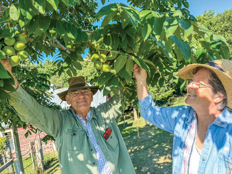
Several of Goeden’s grafted cultivars are growing on Darrell and Martha Ausborn’s 10 acres of land west of Yankton overlooking Lewis and Clark Lake. Ausborn is a retired forester who began in private industry in Florida and Alabama. He later transferred to the Bureau of Indian Affairs where he worked as a forester until retirement.
He and Martha, an Alabama native, chose the Yankton County acreage because, Martha says, “he needed a place to play.”
To stay busy in retirement, the couple set their sights on nut trees. In 2008 they planted a batch of grafted seedlings that included English walnut, black walnut, pecan, Chinese chestnut, heartnut and butternut. As they’ve experimented, the Ausborns have added cultivars from various nurseries as well as grafted cultivars from Goeden.
“For pecans, we’re about as far north as you can get,” Darrell says. “The trees do okay, but some years there aren’t enough summer heat days for the nuts to mature. Last year they did mature, and this year they are growing. We’ll see how far they make it into the fall. If we get a cool September or an early frost, the pecans won’t be there. But the rest of the nuts do produce.”
A visit to the Ausborns’ grove in early August found healthy hazelnut trees, the nuts still tightly wrapped within flower-like green husks. “You have to hunt for the hazelnuts,” Martha said as she searched the branches. “I like to pick them because it’s like looking for Easter eggs. They lay up underneath the leaves. The husk has to dry and turn brown, and the nut will be loose. When you can touch it and it will spin, usually the last week in August, that’s when you can harvest.”

The Ausborns also boasted healthy crops of heartnuts, butternuts, English walnuts and Chinese chestnuts. A Korean pine nut tree looked somewhat out of place but seems to enjoy the Yankton County environment. “That was something out of pure curiosity, just to see if it would grow,” Ausborn says. “In about 30 years you might be able to taste a pine nut, so remember it’s here.”
*****
Nut harvests are modest. The Ausborns spend fall days using homemade equipment to gather, wash and shell their assortment of nuts. Goeden shares his pecans and other nuts with friends and family. They gather every winter with the Nebraska Nut Growers Association for an annual nut evaluation that measures each nut’s size, cracking ability, flavor and quality and quantity of nutmeat. The results help them determine what cultivars are working.
They are also willing to help others. “Without the knowledge and expertise of the Nebraska Nut Growers Association, Darrell and I wouldn’t have had the success that we’ve had,” Goeden says. “Grafting nut trees is an fading art that needs to be passed from one generation to the next in order to push yield potential.”
People like Goeden and the Ausborns will never grow rich from nut production. Ball says a commercial operation in South Dakota is likely not viable. Still, with the right trees, bags of South Dakota-grown hazelnuts or pecans could show up at farmers’ markets and craft fairs. “It’s kind of like farming has gone,” Ball says. “When I was a kid, a family of five could live on a 140-acre mixed farm. Now that’s a hobby farm. Nut production is the same way. It’s hard to get the scale to where you’re actually able to make a living out of it as opposed to supplementing your income. But for a supplement, yes, you can have a hobby that actually pays.”
Dan DeBuhr’s grandmother likely never thought of her tiny pecan trees as a profitable side hustle, but she loved all trees and encouraged her grandson to care for them long after she was gone. “My grandma told me, ‘I’ll never be able to see the pecans, but if you stay here long enough, you probably will,’” DeBuhr recalls. “‘Do me a favor,’ she said. ‘When the trees get big, take a chair on the hottest day, when there’s no wind, and go sit under the trees, because they’ll talk to you.’
“One day in July I was out here working, and it was so hot, no air. So I got a chair and put it right between those trees. All of sudden the leaves were just shaking. That’s what she meant by talking.”
Perhaps they were saying they belong here after all.
Editor’s Note: This story is revised from the November/December 2024 issue of South Dakota Magazine. To order a copy or to subscribe, call (800) 456-5117.


