Posted on Leave a comment

Boating the Springfield Delta

The most claustrophobic experience on water

Yankton photographer Dave Tunge’s aerial view of the delta shows its complex web of channels.

By Katie Hunhoff

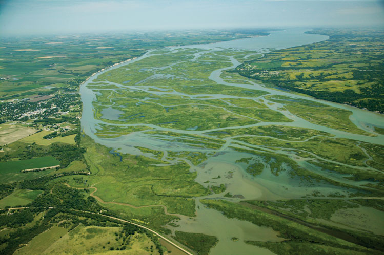
Boaters and adventurers often shy away from the shallow delta that is overtaking the Missouri River by Springfield in southeast South Dakota.

They worry about snags and stumps in the water. The ever-changing channel is confusing. Dozens of sandbars create a maze, and in many places the swamp grass is 10 feet high, making it impossible to see the hills of the shoreline that could provide bearings. Water depths vary from 12 feet to less than a foot.

Snakes, snapping turtles and other critters add to the mystique of a place like nowhere else in the American West.

We wouldn’t explore the delta with just anyone, but Greg Stockholm seemed reliable. Stockholm knows and loves the rivers of America. The tall, cheerful 67-year-old has boated much of the Missouri and Mississippi, as well as the Ohio and numerous other lakes and waterways.

But he’s especially at home on the delta. He boated the Missouri with his dad as a boy, when the reservoir known as Lewis and Clark Lake was sparkly new. Water then extended from shore to shore — more than a mile wide and deep enough for him and his friends to experiment with five-man pyramids on water skis. In 1977 he was skiing with a kite on Lake Poinsett when it sailed skyward and dropped him hard on the water. He was hospitalized for eight weeks, but he was back in a boat almost before his injuries healed.

As a youth, Stockholm watched his father, Alfred, build a 21-foot cabin cruiser. His earliest memories are of taking the wheel of the cruiser at age 4. In 2022 he began construction of a 72-foot sailboat that he hopes to launch near Sioux City, Iowa. His plan is to motor the boat to the ocean, raise its 80-foot mainsail and set off across the Atlantic.

Springfield river rat Greg Stockholm guided South Dakota Magazine publisher Katie Hunhoff through the delta.

Stockholm has operated a body shop for most of his adult life. In his spare time — between fixing cars and building the big sailboat — he still found time to restore a classic 1975 Tahiti jet boat with a 389-inch Pontiac engine.

“Half the boats around Springfield never get in the water here,” he says, because the owners are leery of the delta. We climb aboard the Tahiti at the boat docks on the east side of town. The big engine rattles to life, sending vibrations throughout the little black craft.

Just as we leave the docks and enter the delta, Stockholm points to the Eagle depth finder below the steering wheel of the Tahiti. It reads 6 feet.

“We’re in the main channel right here,” he says.

But then we enter a water alley between two sandbars and the big engine sputters. The propellor has hit sand. The Eagle says we are in a foot of water.

It’s not a problem. Stockholm shifts to “R” and we reverse into a few feet of water.

We’d imagined a delta of grassy sandbars with frogs, toads, crawdads, crabs, flying insects and patches of brackish mud. That’s not the South Dakota delta.

The water seems clean and fresh and there is little mud. It’s mostly sand below the water and on the islands or sandbars. Growing on nearly all the sand is a tall perennial grass called phragmites, an invasive species that is spreading to lakes and wetlands throughout eastern South Dakota. Unfortunately, it creates a dense, nearly impenetrable jungle that deer and other wildlife try to avoid. Phragmites even affects fish because the massive roots dry the marshland and reduce habitat for minnows, frogs and other small creatures.

Stockholm says the U.S. Corps of Engineers, overseer of the Missouri River valley, sends helicopters with herbicide sprayers to attack the phragmites infestation in the Springfield delta. Once the reeds die and turn white, the federal authorities sometimes burn the sandbars. Their goal is to eliminate all vegetation on the sandbars so the endangered piping plover will have better nesting conditions.

It would be nice if the herbicide, which has been approved for aquatic use by the EPA, would enable cattails, Russian olives and wild grasses to regain a foothold, but on our trip through the maze it appeared that the phragmites are winning the war with the Corps.

We saw few signs of wildlife. A lone deer peeked out of the reeds. A massive old snapping turtle, 2 feet in diameter, balanced on a stump in the water.

Stockholm says the river has quieted in his lifetime. “I remember lying awake in bed in our house in town and hearing the honking of geese all night long,” he says.

The throaty baritone of bullfrogs was a regular sound of summer. Beavers, muskrats and other wildlife added to the cacophony of the river. On our outing, there was nary a sound when Stockholm shut down the Pontiac engine.

Still, he says, this is a wild place. “The river is alive. You can never outguess it. It’s always changing, and it probably always will be.”

Two main channels of the old river can be found in the delta, one on the South Dakota side and another below the yellow chalkstone bluffs of Nebraska.

Stockholm sped up the Tahiti for a 7-mile zig-zag journey southwest on the river to the little fishing village of Running Water. Phragmites are there, too, lining the shore by the boat docks. Just beyond Running Water is the Standing Bear Bridge, a 3,000-foot crossing that gives motorists an expansive view of the delta.

West of Running Water is the town of Niobrara, Nebraska, and the mouth of the Niobrara River, which brings several million tons of sediment into Lewis and Clark Lake every year — creating the unusual delta that is slowly creeping eastward. Experts predict that the grassy delta — with its phragmites-laden sandbars — could reach Gavins Point Dam at Yankton if an affordable solution isn’t found.

The sediment is considered a scourge in South Dakota and Nebraska. Ironically, it is badly needed in the Gulf of Mexico where the coastline is disappearing due to erosion and rising sea levels. Before the six dams were built on the Missouri River in the 1940s and 1950s, sediment from the 2,341-mile Missouri — North America’s longest river — flowed unimpeded to the Gulf.

Now it lays above Gavins Point Dam.

Upon reaching the Standing Bear Bridge, Stockholm steered the Tahiti northeast and motored back toward Springfield. Moving with the current, the big motor had easy work. The sun was now at our backs and setting low over the delta. Blue herons began to show up along the shore. Sometimes, the graceful birds craned their long necks and stared. Just one other boat was on the water that night, so we were a rare sight. A curious crane took flight and followed us down the river.

The water widens just west of the Chief Standing Bear Bridge.

“Sometimes I think they want to race the boat,” grinned Stockholm.

Other waterfowl appeared at sunset. A small flock of Canada geese flew in formation from the east.

When we arrived at Springfield, where we’d begun, Stockholm asked if we wanted to see where the delta ends and “the lake begins.” Of course, we did.

So we traveled east just a few miles — past another fishing village known as Apple Tree. A flock of perhaps 50 big white pelicans sat on a shallow ledge.

Stockholm pointed to the Nebraska shoreline, about a mile and a half away, and said he’s quite sure we could walk there. “I doubt the water is more than waist high all the way across.”

If the sediment continues to fill the lake, scientists say the delta will extend all the way to the Yankton dam, 15 miles away. The tallgrass phragmites will surely follow.

We rounded a sandbar and there was open water as far as we could see to the east — a fresh sight after spending hours in the claustrophobic delta.

Editor’s Note: This story is revised from the March/April 2025 issue of South Dakota Magazine. To order a copy or to subscribe, call (800) 456-5117.

Posted on Leave a comment

Scoping the Missouri

Members of the South Dakota Ornithologists Union look for birds at Union Grove State Park between Beresford and Elk Point.

Roger Dietrich was scoping along the shore of Lake Yankton when a Rapid City woman approached him with a question about the tiny Ross’s gull, which had been sighted in the area.

“I’ve gone to Alaska twice and I didn’t see the bird there,” she said.”Is it still around?”

Dietrich pointed to a gull, sitting on ice in the middle of the lake.

The Missouri River is a bird-watching paradise. Hundreds of species of ducks, geese, gulls, loons and other birds congregate in parks, woodlands and farm fields that border its 443-mile corridor. But it still helps to know for what you’re looking.

Every habitat attracts different birds, says David Swanson, professor of biology at the University of South Dakota and author of Birder’s Guide to South Dakota, and habitats vary dramatically along the Missouri as it winds from Nebraska to North Dakota.

Following is a guide, from south to north, of habitat patches and the surprises that await birdwatchers, both the serious birders looking for the rarest”lifer” bird and those who are happy spotting sparrows and swallows.


The Adams Nature Preserve attracts wading birds such as blue herons.

Adams Nature Preserve

Southeastern South Dakota

The Adams Homestead and Nature Preserve near North Sioux City includes many trails.”It has a variety of habitats,” Swanson says.”It has an extensive cottonwood forest that borders the river, and there’s also a little lake called Mud Lake that’s attractive to waterfowl. The ring of trees surrounding Mud Lake can be good for woodland birds, too.”

Mud Lake is approximately a quarter mile from the Adams Homestead parking lot, so a brief hike is required to access it. Wooden observation blinds lie along the trail with a view of the lake.

“The other habitat at the park is a restored open prairie,” he says.”It’s one of the few sites in the southeastern part of the state where you can find Eastern meadowlarks. The common meadowlark in South Dakota is the Western meadowlark, but the Eastern meadowlark is expanding its range in the southeastern part of the state and Adams Homestead is one of the places where you can find those.”

Since first being sighted in 2017 by Swanson and his ornithology students, the Eastern meadowlark has made regular appearances in the open-prairie habitat, often with multiple birds singing among the scattered trees.

“I wasn’t aware at the time that Eastern meadowlarks had started to expand their range, and I heard these Eastern meadowlarks calling,” Swanson says.”I go, ‘That is very unusual.’ We kept walking and saw them and everybody in the ornithology class got to see me geek out over it.”

Though birdwatching at the Adams Homestead is enjoyable year-round, it’s best in spring, summer and fall.”Mostly, it’s hiking the trails during migration and seeing a variety of birds at that time,” Swanson says.”It’s lots of warblers and sparrows, so the migration periods are late April to mid-May. Then in the fall, from mid-to-late August into about mid-September is probably the peak for warblers and vireos, some of which migrate all the way down to Central and South America.”

Sparrows that migrate to the southern U.S. and Mexico slightly later in the year can typically be seen at the Adams Homestead from mid-September to mid-October. Along the river and at the lake, birdwatchers encounter ducks and geese, as well as wading birds like herons and egrets.

“In the cottonwood forest, there are Eastern whippoorwills,” Swanson says.”Those are birds that don’t really get too much out of the southeastern part of the state. Of course, they’re nocturnal, so they don’t start calling until it starts to get dark.”


Least terns can be found on sandbars below Gavins Point Dam.

Gavins Point Dam

West of Yankton

Gavins Point Dam, the southernmost project on the Missouri’s system of six dams, is surrounded by unique bird habitats.

During the summer, hundreds of American white pelicans can sometimes be seen near the dam, while on the river itself, there are piping plovers, still considered a threatened species in most of the U.S., and the least tern, North America’s tiniest tern, often seen flying low over the river and hovering before plunging for prey.

“One of the reasons I like birding is the idea that it would be so cool to fly, and least terns are just the best flyers,” says Roger Dietrich, a local authority on ornithology.”They’ll fly and they’ll see a minnow, and then they dive straight down in the water — and splash!”

In winter, the 2-mile-long earthen dam creates an unusual condition for birds and birders.”Some years, when it doesn’t freeze, like lately, there’s been lots of open water above the dam,” Dietrich says.”Some years, we get lucky and even the Lewis and Clark Marina doesn’t freeze over real early. So, that’s a popular spot where some grebes and loons will stop.”

Black scoters, surf scoters, white-winged scoters and long-tail ducks, which are mainly ocean birds, are known to visit the lake and river in winter.

“I tell people from other places that we have those birds here and they’re just not believing it, because they don’t think of the center of the United States as a place where these birds would show up,” Dietrich says.”And when I say they show up every year, usually, for a fairly long period of time, they just can’t believe that we’re so lucky.”

The common loon migrates through the area, as well as a number of gulls — including Sabine’s gulls, kittiwakes, black-legged kittiwakes and even the Ross’s gull, which is associated with the remote arctic. Crest Road, which passes over the dam, is a good place to observe such birds. It requires no special pass or permit.

“Scan for the birds with binoculars or a spotting scope and chances are, you’ll find something different,” Dietrich says.”Sometimes there are huge flocks, and you can spend hours just scoping the birds there,” he says.”So, if you see somebody there with their scope out or binoculars, stop and ask them what they’re seeing. I’d say 99 percent of the people will be glad to point things out to you, and maybe even let you look through their scope to see what they’re seeing.”

Several snowy owls hung out along the dam road a few years ago.”They were feeding on the flocks of coots that were there.” Wintertime also brings large flocks of lesser scaup, which birdwatchers will scan for specimens of greater scaup, a polar bird that tends to prefer saltwater and is rarely seen inland, Dietrich says.

“It’s the same with the big flocks of common goldeneye,” he says.”People try to scope out the Barrow’s goldeneye, which is another species. It’s more of a West Coast bird, but once in a while, we’ll get one here — always a highlight.”

Bald eagles frequent Gavins Point Dam and some now nest year-round in the tall cottonwoods that border the Missouri.”They’re used to a lot of people around and some of the trees they perch in are right along the local roads,” Dietrich says.”You can see them in action, swooping down and picking up fish. I’ve seen eight or nine at a time on the ice up above the dam, eating the dead snow geese they’ve picked off.”


A pair of Barrow’s Goldeneyes at Fort Randall.

Fort Randall

Pickstown

Fort Randall Dam also hosts a large congregation of bald eagles. Below the dam is the Karl E. Mundt National Wildlife Refuge, which provides habitat for the eagles.

Kelly Preheim, a kindergarten teacher in Armour and a well-known local birding enthusiast, especially likes the wooded area around the Fort Randall Dam.”We’re mostly on agricultural grassland in southeastern South Dakota,” she says.”But the dams have a lot of woodland, forested areas, and I enjoy walking on the trails.”

She found 71 bird species on a recent camping trip to Pickstown.”In the morning, oh my goodness, the singing,” she recalls.”My husband’s like, ‘I can’t get any sleep. It’s so loud here!'”

A hike to the tailrace, the channel below the dam that carries water away, will often be rewarded.”Fish that go through the dam come out somewhat stunned in the tailrace,” Preheim says.”Then, all these birds, like gulls and eagles and certain ducks, eat those fish.”

Like nearby Gavins Point, Fort Randall Dam is also home to many types of waterfowl in autumn and winter.”There are a lot of different ducks on the scene, hundreds and hundreds, if not thousands, of different ducks there at a time,” Preheim says.”I saw a brown pelican one time. That’s actually an ocean bird.”

Other surprise visitors at Fort Randall include a yellow-billed loon, typically associated with Alaska and America’s western coast, and a great black-backed gull, which is an Atlantic coastal bird, Preheim says.

Scarlet tanagers are often found in South Dakota but summer tanagers, a rare visitor, might also be seen around Fort Randall.


Pelicans near Big Bend.

Big Bend Dam

Fort Thompson

The best birdwatching at South Dakota’s northernmost dams — Big Bend and Oahe — occurs from April through May and from September to November, according to lifelong birdwatcher Ricky Olson, who lives at Fort Pierre.

Big Bend has fewer access roads and trail amenities than Oahe and the other dams, but it has its own charms. Ospreys nest below the dam and brown pelicans have been spotted.

“Once in a while, in the wintertime, you get a Brant goose at Big Bend,” a seacoast bird.”I run down to Big Bend at least every two weeks in the winter to see what’s there,” Olson says.

Big Bend also attracts smaller goose species, including snow geese and white-fronted geese, both of which are common to the area.”In the fall, it’s neater to go to Big Bend,” Olson says.”Also, the shad and minnow species will be in the shallows then, and you’ll get all kinds of cormorants and pelicans and hundreds of gulls in these frenzies where they’re all feeding, and the gulls are trying to steal from everybody.”


Canada geese along the Missouri River.

Oahe Dam

Central South Dakota

Ring-billed gulls, herring gulls and California gulls may be sighted at Oahe, as well as the arctic tern, a mega-find for birders.

A spectacle occurs during flooding when Oahe Dam’s hydraulic turbines are running.”It’s a feeding frenzy. You get thousands of gulls, maybe 20,000, below the tailrace in a half-mile stretch,” Olson says.”It’s like a snowstorm. Thousands of people come to watch the ‘gull snowfall.'”

Oahe also has cliff-dwellers.”In the sand layers in the cliffs, in the holes, there are barn owls nesting,” Olson says.”They dig their own holes, and often, they’re near where colonies of bank swallows have dug holes.”

In autumn, Sabine’s gull may be spotted.”It’s very pretty. It’s black and white with half a diamond on the wing,” Olson says.”We also get Bonapartes and Little gulls, which is a little gull, and we get some of the big ones. Once in a great while we get the great black-back, which is the biggest gull.”

Gulls breed on a few islands along Oahe, Olson says.”There are only a few places in South Dakota where that happens.”

Another rare visitor to Oahe, among the sea ducks like the scoters and the long tail duck, is the occasional coastal harlequin duck in the tailrace.

“We get loons,” Olson says.”Sometimes we get the Pacific or the yellow-billed or red-throated loon, which are rare for our state.”

Further north on Oahe, retired biology teacher Stan Mack says opportunities are available even in Mobridge’s city limits.”There’s a walking trail along the south side of town. Just follow Main Street to the river and walk west and you’ll see the ducks and geese and gulls that sit on the water.”

Mack says Indian Creek (east of Mobridge) and Indian Memorial (across the river to the west) offer trails and habitat.

Mack doesn’t walk well enough to explore like he once did, but the birds will come to him.”I’m doing a feeder watch for Cornell University. Right now, I’m looking at a collared dove — we never saw them before — and I see about 16 more picking up seeds on the ground.”

Editor’s Note: This story is revised from the March/April 2025 issue of South Dakota Magazine. To order a copy or to subscribe, call (800) 456-5117.

Posted on Leave a comment

The Yankton to Marty Trail

South Dakota Magazine intern Ava Brandt met Digger at Mensch’s Greenhouse in Avon.

A golden dog named Digger met us at the door of Mensch’s Greenhouse, his tail wagging like a windshield wiper. Two cats lolled on a flower worktable and a dozen colorful cockatiels chirped from two cages near the petunias.

Any traveler will crack a smile at Mensch’s Greenhouse in Avon — and that’s fortunate because for the most part this Yankton-to-Marty loop can be a solitary journey, even though it visits seven small towns in South Dakota’s populated southeast corner.

We began the loop early in the morning because of a tip that the Tyndall Bakery has amazing donuts and pastries, and some days they sell out. We had two stops to make before the bakery.


The Lakeport Church in rural Yankton County dates to 1884.

Chalkstone Church

We drove 8 miles west of Yankton on Highway 50 to 431st Avenue, then turned right to the Bruce and Donna Schwarz farm. Drive slowly through the farmyard — the Schwarzes don’t mind — and you come to a small church built of the yellow chalkstone found along stretches of the nearby Missouri. Neighbors keep up the church and mow the cemetery, which features Czech surnames still common in the area. This is Czech country, settled by pioneers from Bohemia and Moravia who began to arrive in 1869. Their first settlement was Lakeport; only the little yellow church, constructed in 1884, has survived.


A wooden church is among the historic buildings preserved at the park in Tabor.

TABOR: CZECH CAPITAL

A few miles further along Highway 50 is the town of Tabor (pop. 405), founded in 1872. Tabor is famous for its annual Czech Days celebration in June. Parking is more plentiful on the other 362 days of the year, so stop on Main Street and stretch your legs by walking through the quaint pioneer village which includes a tiny wood church that was built at Lakeport even before the chalkstone church. Now it is well-kept in the Czech Preservation Society’s heritage park along with several other antiquated structures.


Magazine interns Rose Lane (left) and Ava Brandt at Tyndall’s Eiffel Tower, a fancy flagpole that measures 100 feet.

TYNDALL’S TOWER

One wonders if Gustave Eiffel, engineer and namesake of the tallest structure in Paris, would be flattered to see the imitation in Tyndall.

Tyndall’s”Eiffel” is more than 1,000 feet shorter than Gustave’s, but nearly as old. It was constructed in 1898, just nine years after the original was completed to honor the centennial of the French revolution.

The replica stands on the lawn of the county courthouse, west of downtown on 18th Avenue. But before you visit the tower, stop at the Radack family’s bakery. We dilly-dallied too long, and the cases were nearly empty, so we missed out on the Tyndall Roll, a Bismarck-like pastry filled with white cream and topped with crushed peanuts. No one knows when the legendary roll was created, but the bakery traces its history to 1905.


Carol and Vern Tolsma at their Avon greenhouse.

AVON’S GREENHOUSE

Feeling lonely in southeast South Dakota? Just visit Vern and Carol Tolsma’s Mensch Greenhouse and Flower Shop along Highway 50 in Avon.

Carol’s grandmother, Ada Mensch, started the greenhouse in 1957. Imagine how many flowers have bloomed, thanks to Ada, in 67 years. And how many people have enjoyed the garden bounty that took root here.

The flowers and plants come with free advice. Did you know you should only water tomato plants when absolutely necessary? Vern says a thirsty plant sends roots deep into the soil, making it strong and adding taste to the fruit.

Digger, the greenhouse dog, wags and nuzzles anyone who’ll take the time. Cats and cockatiels also share the space. The cockatiels are orphans who lost their owners and found refuge here.

The Tolsmas tend a 2-acre garden near the shop, and they sell produce, canned goods and amazing pickles. They occasionally set out a table of freebies that need a home.

Some days, Vern wears a blue t-shirt that says it all:”I Love Gardening From My Head to My Tomatoes.”


Richard Langdeaux helps keep Wagner’s park looking beautiful.

A WALK IN THE WAGNER PARK

Follow Highway 50 northwest. South Dakota’s Czech heritage extends into Charles Mix County and the city of Wagner (pop. 1,603), the largest town on this loop tour. Wagner has all the amenities you might want — a coffee shop, restaurants and a grocery store.

On the west side of town, near Highway 50, lies a little lake and park that would be the envy of any city in America. The lake was created when a dam and rock structures were built in the 1930s by WPA workers. Today the park includes two walking bridges, flower gardens, trails and even a small waterfall. This is the best opportunity of the day for a walk.

Richard Langdeaux, a Santa Claus look-alike who was collecting trash in the park, told us that the stone buildings along the lake were once a Scout camp. Artesian springs keep the lake full year-round.

Wagner also offers an impressive museum, operated by the Charles Mix County Historical Society. The collection is known for its Czech exhibits, as well as artifacts from the Yankton Sioux culture that predates the pioneers.


Michael Rouse helps maintain the ground around Marty’s St. Paul Catholic Church.

MARTY’S AMAZING CHURCH

Drive west of Wagner for 6 miles to 388th Avenue and turn south for another 6 miles to Marty. The one and only enterprise is a boarding school started by the Benedictines in 1924 and now operated by the Yankton Sioux Tribe.

Alongside the school is St. Paul Catholic Church, built by volunteers — Indians and non-Indians — in the early 1940s of Indiana sandstone, mined from a quarry near St. Meinrad Archabbey, which founded St. Paul’s.

The steepled church (167 feet!) is surrounded by tall trees and other structures, so it’s hard to appreciate from afar. Exit your car and walk about the churchyard, where there are statues of Kateri Tekakwitha, the first Native American saint, and St. Theresa, patroness of missions. On most days, the church doors are open; inside, St. Paul’s looks like something you might see in a European city except that the murals, stained glass and other art are rich in Native American themes.


The tallest stone in Greenwood Presbyterian Cemetery marks the grave of Struck by the Ree.

STRUCK BY THE REE

Follow the road south of Marty for about 7 miles and a few curves. You’ll come to Greenwood Presbyterian Cemetery, where the tallest stone marks the grave of Struck By The Ree, a maligned and misunderstood leader of the Nakota. He was born in 1804, as Lewis and Clark came through the river valley. Legend says the explorers wrapped the baby in an American flag and proclaimed he’d be a great leader.

Struck By The Ree did grow to be a wise chief — an environmentalist, a feminist and a peacemaker. He urged pioneers to preserve the timber resources of the river valley. He pleaded that both Nakota and white men respect the Native women. And though he first fought the intrusion of the white civilization, he eventually recognized that it could not be stopped (ìthey are like maggots Ö”). He became a lead negotiator in the 1858 Treaty. Decades later, after the treaty was broken and his people found themselves hungry and hopeless, he was often persecuted; his cabin was burned, and his horses were stolen.


A tall memorial near Greenwood commemorates the 1858 Treaty.

Treaty Memorial

Continue south and you’ll soon come to another memorial, erected to honor Struck By The Ree and seven other Native American signers of the 1858 Treaty, which gave the government more than 11 million acres for $1.6 million and established a reservation for the Nakota.

The monument was constructed in 1907, topped with an obelisk. A few decades ago, vandals toppled the obelisk — a posthumous insult to Struck By The Ree, a century after his death in 1888. It has since been restored.


Springfield sits above a growing delta in the Missouri River.

A MISSOURI RIVER DELTA TOWN

Drive south from the treaty marker and you’ll come to the tiny community of Greenwood, once the hub of the Yankton Sioux Tribe. At Greenwood, if you are not in a hurry, turn right and follow the river for a mile or two for scenic views. Then return and continue east along the Missouri.

Eventually you’ll come to 312th Street, and then to Highway 37 which will lead you to Springfield, once South Dakota’s smallest college town. Thirty years ago, the University of South Dakota/Springfield was closed, despite furious opposition, and the campus was converted to a prison.

Townspeople feared that the prison would be the ruin of Springfield, but it has persevered. Norm’s, once a favorite hangout for collegians, still serves burgers and beer. A company known as Mr. Golf Car parks more than 200 golf carts along Main Street. A museum keeps the history of the college alive, and anglers come to fish the river.

Springfield still has a post office, bank and library — plus several eateries. On its eastern edge is a veteran’s memorial with a panoramic view of the river.

The highway sign lists the population at 834. That doesn’t count the 1,200 prisoners who live there.


Six unknown soldiers of Lt. Col. George Custer’s 7th Cavalry are buried in the Bon Homme Cemetery.

APPLE TREE ROAD

For a final treat on your loop, turn east onto Apple Tree Road (a mile north of Springfield).

A few miles down the road is a spot known as Apple Tree (though the state Game, Fish and Parks Department calls it Sand Creek). It consists of a campground and cabins, a boat dock and a little peninsula where you can walk out among the reeds and see where the invasive delta ends and Lewis and Clark Lake’s open water begins.

This was once a delightful place to enjoy the bellowing of giant bullfrogs. They were silent on our stop. Perhaps they dislike the phragmites, an invasive wetland plant that is taking over.

Continue east on Apple Tree Road and you’ll soon pass the tidy Bon Homme Cemetery where a large stone memorial marks the graves of six soldiers who traveled with Lt. Col. George Custer and his 7th Cavalry in 1873.

As Custer’s entourage camped at the nearby town of Bon Homme for four days, six became ill and died. Historians speculate that they contracted typhoid fever. The six were initially entombed at Snatch Creek and then reburied at the cemetery in 1893. In 1922 the large marker was built in the cemetery to give some measure of respect to the nameless six, who might otherwise have perished at the Battle of the Little Bighorn in 1876.


A replica log schoolhouse stands near the Bon Homme townsite.

BON HOMME WAS A TOWN

Continue south on Apple Tree Road and you soon come to a curve near the old community of Bon Homme. At the curve is a monument to the first schoolhouse in the Dakotas. A small replica of the 1860 log schoolhouse was erected in 1910 by pioneers, and it remains there today. Care to skip a rock in the river (or fish or launch a boat)? Just follow the gravel road south at the curve for less than a mile and you’ll drive right up to the water’s edge and a sandy beach.

Back at the curve, head north to Highway 52. It will lead you east to Highway 50, which takes you past the chalkstone church and on to Yankton.

Editor’s Note: This story is revised from the January/February 2025 issue of South Dakota Magazine. To order a copy or to subscribe, call (800) 456-5117.

Posted on Leave a comment

The Paddlefish Opener

Boats dot the Missouri River near Yankton for the annual paddlefish season opener on October 1.

Fishing is often a solitary sport in South Dakota, where anglers drift and cast on massive reservoirs, or on prairie rivers that flow for hundreds of miles. That changes every Oct. 1, however, when hundreds of people gather along a very short stretch of the Missouri River for the opening of the month-long paddlefish season.

Paddlefish are filter-feeders, meaning they won’t bite traditional bait, so they are caught by snagging hooks that are cast into the tailwaters of Gavins Point Dam, just a few miles west of Yankton. Men and women cast and drag, again and again, somewhat like fly fishing but less ballet and more muscle. They fish from boats or the rock-strewn shore. Some stand atop a tall concrete wall on the north side of the dam. When a fish is caught, all the anglers and spectators watch.

Paddlefish is a primitive species that swam eons ago with the dinosaurs. Due to its size and shark-like appearance, it seems like a creature more fit for the world’s oceans rather than the lakes and rivers of middle America.

The largest ever caught was speared by an Iowa fisherman in 1916. It weighed 198 pounds. The South Dakota record is a 127-pounder landed by Bill Harmon in 2014 at Lake Francis Case. Hundred-pound fish measuring 4 to 5 feet are not uncommon.

Bryan Mendlik, Scott Mendlik and Kellen McClure caught and released a “slot” paddlefish below Gavins Point Dam that measured just under 45 inches.

Landing such a large fish is no easy matter. On some occasions, it takes many minutes and several men. As soon as a fish is brought out of the water, the angler and his friends grab a tape measure, but they don’t stretch the tape along the paddle-like snout, which can be one-third of its overall length; the scientific measurement is from the eye to the fork in the tail.

The sport of paddlefishing is heavily regulated in South Dakota, and one of the rules states that fish between 35 and 45 inches must be immediately released because they are in their breeding prime. The six Missouri River dams greatly interrupted the natural spawning of the great fish. Much of the slack has been replaced by artificial breeding programs in hatcheries, but paddlefish do still breed in the wild.

Biologists want to give them every chance to do so, and the anglers obviously agree because there’s always an urgency to get every fish measured and then released when it’s within the range.

The snagging season at Yankton runs the month of October. There was a time when it began on Oct. 1 and then concluded after a certain quota of fish were harvested. That created a bedlam of action, as everyone rushed to snag a fish before the season ended. The river and shoreline became so congested that authorities deemed it unsafe.

Naturally, such mayhem created more regulations. Today only 1,600 licenses are made available in a June drawing. (A May season is held at Lake Francis Case, where just 350 licenses are allowed.)

License winners at Yankton now have the entire month of October to bag a fish, but opening morning is still a sight to behold — especially when it turns out to be a classic autumn morning with blue skies and gold leaves on the cottonwoods that shade the river.

Anglers and spectators alike mark Oct. 1 on their calendars.

Editor’s Note: This story is revised from the September/October 2022 issue of South Dakota Magazine. To order a copy or to subscribe, call (800) 456-5117.

Posted on Leave a comment

Ship in a Bottle

German prisoners of war were put to work harvesting beets on Jack Rathbun’s farm near Nisland.

The war hit home for the Lungrens on a Sunday in December.

“I can remember the Sunday when the Japanese bombed Pearl Harbor,” says Don Lungren of Pierre, who grew up in a German-speaking home near Vale.”We went to church. We came home, and on Sunday, Dad always turned on the radio to hear what the markets were going to be on Monday morning in Sioux City. Most of the time we didn’t have anything to sell, but he had to know what the markets were.”

On that Sunday in 1941, his father tuned in the set, as always; but he might have let it stay on longer than usual.”They were making a lot of noise on that radio, I can remember that — yelling and stuff,” Lungren recalls.”Dad shut it off and he told Mom he was going to see Grandpa.”

Lungren’s father returned with a strict order:”Henceforth, we don’t speak German anymore.”

The attack on Pearl Harbor brought the United States into the war against Japan and its ally, Germany. Perhaps because of the mistreatment of ethnic Germans in the U.S. during World War I, and perhaps because of fears that Japanese and German speakers might be suspected of harboring sympathies with the enemy, the family stopped speaking German then and there.

That Sunday the Lungren children also realized Germans were on the other side of the war. And if they had any doubts that Germans were the adversaries, there was more proof. South Dakota would be one of the places where German prisoners of war were stationed as World War II dragged on.

The first prisoners of war arrived in America in May 1942. Historian Arnold Krammer, who has written extensively about the era, notes that not only Germans but also Italian and Japanese soldiers would spend time in American internment camps before the effort ended in July 1946.

“It is remarkable how many people don’t realize that we held nearly 425,000 German POWs (as well as 53,000 Italian and 5,000 military Japanese prisoners) in some 550 camps across the country. They worked in factories, hospitals and brought in the crops since our boys were overseas fighting in the war,” Krammer told us.

In South Dakota, German POWs ended up in parts of Meade and Butte counties doing fieldwork; in Yankton doing bank stabilization work on the Missouri River; in northeastern South Dakota; and in the Sioux Falls area.

“Every farmer in the valley here used German prisoners for a couple years,” says David Rathbun of Nisland, who was about 9 and 10 at the time his family benefited from POW labor in the fields. His brother Grove, four years older, would drive the truck when they went to fetch prisoners from the Civilian Conservation Corps camp at Orman Dam.

The Rathbuns transported prisoners in their 1937 Ford beet truck. An American guard followed in the family’s Model A pickup.

“It was an old CCC camp in the’30s, and the government turned it into a POW camp. It had machine gun towers and barracks and the whole works, big fence,” Rathbun says.”We’d go up in a truck, get a load of German prisoners, maybe 20 at a time, and haul them back to the farm and they’d work. They had to do so much in a day. I’ll give them credit, they were hard workers.”

During threshing, the German soldiers gathered bundles of barley, oats or wheat into wagons. In that era before combines were common, they also pitched bundles into the threshing machine.

With the sugar beets, the POWs took on many tasks: thinning the beets, hoeing them when they were bigger, pulling them and taking the tops off, loading them on trucks for transport to the railroad, where they were loaded on cars and taken to the factory for processing.

There were also prisoners stationed at nearby Fort Meade. The prisoners came from different sectors of the war, Rathbun recalls.”North Africa was the first ones we got. They came in’43. That’s when we got Rommel’s Afrika Korps prisoners, and they were ornery bastards,” he remembers, referring to the German expeditionary force that fought in Africa under Erwin Rommel, one of Hitler’s favorite generals.”They were the old Nazi type. They stabbed one of their own prisoners, killed him with a butcher knife, up at Orman Dam at the prison camp because he was too friendly with American guards.”

Krammer says such incidents weren’t uncommon, though often concealed by the prisoners.”Almost every camp held a minority of die-hard Nazis who often terrorized the others and sometimes murdered one or two, listing the deaths as suicides.”

The prisoners stayed for growing season, and after harvest were moved to other parts of the country.”They shipped them all out, I don’t know what they did with them,” Rathbun says.”And then in’44, we got prisoners from Normandy. They were just run-of-the-mill German soldiers. They were different. They were damn glad to be out of that war. They didn’t mind working in the beet fields.”

Krammer cites studies saying about 40 percent of German POWs were pro-Nazi. Eight to 10 percent were considered fanatics in their devotion to the Nazi cause, while another 30 percent were”deeply sympathetic.” But just as Rathbun suggested, many of the German POWs were not Nazis.

The prisoners were given small breaks to split up the hours of labor.”Our place had the Belle Fourche River running through it. If they got done early in their work, the guard would let them go swim in the river, and they really liked that,” Rathbun says.

There were even stories that the guard would take a dip with the prisoners now and then.”He did, actually,” Rathbun confirms.”I saw that happen. The guard went swimming and left a sergeant, German sergeant, sitting on the hillside looking for the colonel.”

Locals would often practice German with the prisoners.”There’s a lot of German around here. Our neighbors were Low German, I think, and the prisoners were High German, but they could understand each other. They’d talk all the time.”

Another mode of communication was the universal language of food and drink. Don Lungren recalls that his parents and grandparents, Germans themselves, coaxed extra labor out of the POWs.

“They would make a big 2- or 3-gallon pail of chicken noodle soup, and man, I’ll tell you, they could pick cucumbers twice as fast. And Grandpa, he made better than that. His bribe was that if they would look at the end of the trees, by the hog house, there would be some beer there if they would get those cucumbers picked today. They had them done by noon, I think.”

After long days in the Butte County beet fields, prisoners sometimes enjoyed a swim in the Belle Fourche River.

Lungren said other locals would do favors for the POWs.”My family and most of the German families always gave them a treat — chicken noodle soup from the old roosters and that sort of thing and beer at the end of the grove in the trees. The guard would come. Grandpa would loan the guard his shotgun and the guard could go shoot pheasants. And because the guard couldn’t get the pheasants home, I suppose Grandma cooked the pheasants and fed them to the prisoners.”

Sometimes the farmers got more than they asked.”Grandma told one of the prisoners she wanted some little cucumbers because she wanted to make baby dills,” Lungren said. His grandmother had business to tend to, but when she got back to the field, the Germans had picked two bushels of tiny cucumbers — far more than she needed.”We had baby dills for years.”

Marian Ruff added that for German-speaking families, even though many of them had immigrated to America from German communities in Russia, it was awkward having German POWs work in the fields.

“My family, like the other German families, was looked down on because of the war — because they were Germans,” she said.”With the POWs, I think we felt sorry for them because of the way they were treated. They would bring this truckload of guys out to the Vale area and they would have two armed soldiers with them with rifles in case they tried to escape. They were supposed to shoot them.”

The guards weren’t just for show, Krammer says.

“There were escapes aplenty, but most were caught within three days,” he notes. But, he adds that many prisoners quickly figured out they would be treated decently in America.

“Those assigned to American farms were well-treated and modern flea markets still have POW-made handicrafts which they gave to the children of farm families,” Krammer said.

That was the case in South Dakota, too, Marian Ruff said.”They were just really happy to get out of the prison situation and do something. Several of them put together some ships inside of wine bottles. We have one of those. One was given to my grandpa. Several of the families that these prisoners worked for ended up with one of these ships inside of a bottle. It always fascinated me because I had no idea how they did it. Someone said to me recently, ëWell, they sawed the bottom of the bottle and put the ship in and sealed the bottom back on again,’ but I don’t know if that’s what they really did or not.”

And no one knows what it meant to a German soldier, either — building a ship inside a bottle in a prison camp to give to a German farmer in landlocked South Dakota.

David Ruff of Spearfish, Marian’s husband, grew up near Nisland during the war. He spoke German well enough to understand the German POWs who worked for his father and some of the neighbors.

The Rathbun family dog often provided canine companionship for Germans working the fields.

“I often wondered if they didn’t have feelings knowing that they were in a country so far from their homeland and had people there that could speak their language. I think many of the prisoners were quite pleased to find that there were German-speaking people here. They were appreciative of the extra food that was given them and the friendliness of the farmers that they worked for.

“I don’t know if I personally asked one of them or what, but somehow or another in conversation, I learned from them that they were quite pleased with the treatment they were receiving here. I’m not sure exactly where they became prisoners of war, but they mentioned that when they were in France, they were required to drink out of the troughs that the livestock drank out of.”

POWs also made an impact on the other side of the state. Yankton-area historians Lois Varvel and Kathy K. Grow reflected on the German POWs stationed in Yankton in their 2001 book, The Bridge We Built: The Story of Yankton’s Meridian Bridge. They noted that the Yankton Press & Dakotan reported on April 3, 1945, the arrival of the first contingent of German POWs from the Afrika Korps to take part in Missouri River bank protection work. Officials wouldn’t tell the newspaper how many German POWs would come to Yankton, citing policy on POWs, but the newspaper understood they would make up”a sizable force.”

The POWs worked on a project to make sure the main flow of the Missouri River steered clear of the city of Yankton’s water intake. The work had side benefits for the Meridian Bridge.”We had prisoners of war trucked in from Algona, Iowa, and they did revetment work on the Nebraska shoreline. That was their contribution to protecting the Meridian Bridge,” Varvel says.

After the war ended, most of the 375,000 German POWs went back to Germany — but not all stayed there. Some liked what they had seen of life in America. The United States didn’t track the number of former German POWs who ended up immigrating to the land of their captivity; but it was substantial. Krammer notes that John Schroer, a former POW who immigrated to America after being held as a POW in Alabama, estimated about 5,000 POWs made a similar move. Some reportedly returned to South Dakota, too, where the enemy they had fought showed them decency and kindness in victory.

Editor’s Note: The tally of German prisoners of war in South Dakota at any one time during World War II was a floating figure because they rotated in and out of different states depending on the local harvest and other demands. Curt Nickisch, a South Dakota Public Broadcasting journalist at the time, wrote a story for South Dakota Magazine in 2001 in which he reported the number at more than 1,200 POWs through 1944 and 1945. There are also several books available, including Nazi Prisoners of War in America by Arnold Krammer. This story is revised from the March/April 2018 issue of South Dakota Magazine. To order a copy or to subscribe, call (800) 456-5117.

Posted on Leave a comment

A Photographer’s Playground

I’ve never outgrown my fascination for toys. A few years back a friend asked me to lead a workshop photographing toys. My first reaction was,”Who’s going to sign up for that?” He suggested I do a Google search and it opened a whole new creative doorway and reason for collecting toys. I discovered there are thousands of people around the world creating very fun photographs with toys.

Toys now accompany my camera on just about every trip. These images are some of my favorites from around South Dakota.

Chad Coppess is the photo editor for South Dakota Magazine

Posted on Leave a comment

Making Dignity

Dignity, a 50-foot-tall stainless-steel tribute to indigenous culture, stands on a Missouri River bluff near Chamberlain. Photo by Chad Coppess

Editor’s Note: This story appeared in the September/October 2016 issue of South Dakota Magazine in conjunction with the unveiling of Dale Lamphere’s grand sculpture Dignity of Earth and Sky along the Missouri River near Chamberlain.

For a year and a half, anticipation built across South Dakota and beyond about Dignity, Dale Lamphere’s 50-foot sculpture that overlooks the Missouri River from a dominant bluff. Millions see it every year as they drive past Chamberlain on Interstate 90.

The stainless-steel statue depicts a Native woman with a star quilt and is both traditional and boldly innovative in design. The traditional: the figure of the woman whose dress, leggings and moccasins are authentic to the mid-1800s, and whose face is an amalgamation of three Lakota women Lamphere used as models. The innovative: motion and changing light in the quilt, with more than 100 blue diamond shapes that move with the wind, fluttering”like an aspen leaf,” Lamphere explains.

Rapid City entrepreneurs Norm and Eunabel McKie put more than a million dollars into the project. They speak of Dignity as”alive” and, Norm says, carrying a burden of responsibility”to inspire all people to maximize their lives, and also to combat suicide,” sadly prevalent on nearby reservations.

South Dakota Artist Laureate Dale Lamphere’s Dignity took shape during the summer of 2016.

The McKies, owners of the McKie Ford/Lincoln car dealership in Rapid City, started talking in 2008 about giving something back to the state that’s been so good to them. Norm went to another Rapid City businessman, architect Pat Wyss, and over time they discussed possible projects. The day came, Norm remembers, when he realized”we could have this iconic sculpture, on the Missouri, in the heart of the state.” Wyss remained with the project from those conceptual discussions to placement at Chamberlain. He is landscape architect for the site, incorporating the hill’s natural slope toward the highway into the pedestal. The McKies and Wyss knew that in Lamphere, they were involving not only an artist of the highest caliber, but someone who shared their deep respect for South Dakota’s Native peoples.

Dignity also contributes to South Dakota tourism, an aspect of the project that excites supporters for reasons beyond revenue. The statue shines a light on the state’s center, too often overlooked by visitors, and makes a powerful statement about modern South Dakotans’ respect for the region’s original residents and cultures.

As South Dakotans know well, these art forms can take a long time to reach fruition. In this case, though, things moved swiftly after a lunch with Gov. Dennis Daugaard where the Dignity concept was explained in detail.”Let’s make this happen,” the governor said to staff who were present. State government quickly committed to having the statue stand on South Dakota-owned land, at the busy I-90 rest area just east of the river and south of Chamberlain, a place offering a sweeping view of the Missouri, bluffs and prairie.

Lamphere gave the project instant credibility. He’s been a professional sculptor for 50 years, with his main studio in the Black Hills foothills near Sturgis. Lamphere has more than 60 major commissions to his credit across the United States, from the Basilica of the National Shrine in Washington, D.C., to art at the Eisenhower Medical Center in southern California. Recent pieces have been installed in Dallas, Kansas City, Chicago and San Antonio. In his home state, Lamphere’s work is prominent at the state capitol building and public venues from Sioux Falls to Spearfish. Human subjects range from spiritual figures to strong and resilient residents of the Great Plains, many of them women.

Over his career, Lamphere has embraced big-scale sculpture (consider his 33-foot tall Sacred Heart of Jesus and Immaculate Heart of Mary, Queen of Peace works at Sioux City, Iowa). That quality draws inevitable comparisons to two historic South Dakota sculptors — Gutzon Borglum (Mount Rushmore) and Korczak Ziolkowski (Crazy Horse Memorial). Lamphere is quick to say he doesn’t consider himself in that league, a self-assessment over which others might squabble. In 2013, the day after he was presented the Governor’s Award in the Arts for his lifetime of distinctive creative achievement, Lamphere was greeted with a long ovation in the state legislature chambers — applause any high-ranking political leader would envy. In 2015 he was named South Dakota Artist Laureate.

More than 100 blue diamond shapes flutter with the wind “like an aspen leaf,” Lamphere says.

Lamphere began creating Dignity by first drawing the form, then sculpting a one eighth-scale model. He communicated regularly with the McKies, who, he notes,”let me pursue my highest vision.”

That vision — including incorporation of light, color and fluttering movement in the quilt — stemmed almost entirely from Lamphere’s imagination.”One of the advantages of living out here in relative isolation is how I have no idea what the rest of the world is doing,” the sculptor says.”So I play around in my imagination.”

The spot where the statue began taking form, where Lamphere multiplied precise measurements from the model and transferred them to steel, is truly isolated. It’s a worksite he’s used before, about 44 miles east of Rapid City on Highway 44, near the Cheyenne River. The location makes it easily accessible to Native people who live in rural southwestern South Dakota, and many stopped by to offer encouragement.”That means a lot,” Lamphere says.

For visitors, the site felt more like a ranch where workers would gather for branding rather than creating art. The Black Hills could be seen off in the distance, with miles of golden prairie in between. About 200 buffalo roam the ranch, and stacked hay bales and tractors decorated the homestead. Dozens of colorful and loud peacocks added flair.

Lamphere fit right in at the Spirited Winds Tatanka Ranch, with his western attire and manner. A shed served as the work base, crammed with tools and home to 30 or 40 kittens and an antler collection. But in front of that shed Dignity rose, surrounded by scaffolding for workers.”They have no idea,” Lamphere quipped,”how tiring it is for me to stand on the ground and yell instructions up to them.”

The ranch is in Tom Trople’s family. Trople has been Lamphere’s chief welder for three decades. Trople had a quip of his own.”These days Dale is pretty understanding that you can’t bend metal every direction — although sometimes he wants to.” Trople has worked on about 20 of Lamphere’s large-scale works, taller than 20 feet.”During that time, Dale’s become more like a brother than employer,” Trople says.

Lamphere transferred measurements from a scale model to the stainless steel sculpture, which took shape on a ranch east of Rapid City.

The involvement of highly regarded sculptors Jim Maher, Andy Roltgen and Grant Standard made the crew something of a dream team. Another important contribution came from Brook Loobey, an automotive paint expert who tackled the challenge of experimenting with colors for the quilt’s diamond-shaped pieces and implied beadwork. He and Lamphere studied color shades in the sun and imagined how those colors might change under different shades of natural light.

Workers dealt with windy conditions along the Cheyenne, which reminded them that the wind is a factor along the Missouri, too. Early on, Lamphere worked with Albertson Engineering of Rapid City to make certain Dignity withstands the most brutal prairie blasts South Dakota can produce. Openings through the quilt, where the diamond shapes hang, help with the wind load.

In considering Dignity‘s full impact, more is at work than the intentions of the artist, benefactors and state of South Dakota. The venue — this exact bluff — witnessed complex history that is intertwined with the art’s statement. Lewis and Clark’s party camped directly across the river in 1804, and traditionally their story has been interpreted as a grand American adventure, with a Native woman playing a key role. But as historians and activists hammered home during the expedition’s bicentennial, those who followed the Lewis and Clark route brought diseases that devastated Native peoples of the Great Plains, Rocky Mountains and Pacific Northwest. Below the bluffs are a rail bed and trestle, reminders of the great political power railroads wielded in opening West River country to immigrants, greatly reducing reservation lands the Lakota people believed would be theirs forever. And the water below the bluff is called Lake Francis Case as often as the Missouri River, because dams completely altered South Dakota’s stretch of the river in the 1950s and ’60s and further stole reservation acreage.

Despite those and other historical indignities, the sculpture boldly proclaims that South Dakota’s Native cultures are alive, standing with dignity.

Posted on Leave a comment

Serenity in the Pocket

The Pocket features Missouri River bottomlands and rough breaks rich with native grasses, ideal for grazing cattle.

It was often a spontaneous decision motivated by the appearance of a fall storm front out of the northwest. In many ways we were like the migrating ducks and geese we were pursuing, driven half by the elements and half by instinct.

We would load into my friend Wes’ blue 1959 Chevy surrounded by the warmest clothes we could find at the Salvation Army, including vintage World War II wool storm coats and flight pants. Being 15, Wes had a learner’s permit that allowed him to drive from dawn to dark and no further than 50 miles from our hometown of Mitchell when not accompanied by an adult — limits that we constantly pushed, often leaving just as the sun set.

Our destination was his grandfather’s ranch in a little-known place called The Pocket, a farm and ranch neighborhood which lies just west of the Missouri River’s historic Big Bend. When we arrived in the dark and trudged through the front porch of the ranch house with our shotguns and clothes — past the saddles, spurs, branding irons and wire stretchers — often his grandfather Duffy wasn’t home. But when we woke before first light, he would always be seated at the kitchen table with a cup of hot instant coffee cradled in his hands, his eyes sparkling at the commotion of the gaggle of half-crazed boys around him.

A rodeo rider in the 1940s, Duffy always told us a story or two about life in The Pocket as he made us flapjacks and eggs before we headed out into the cold to wait for the geese and ducks to rise off the river and fly for the wheat and corn fields on the hills above.

Duffy had been known not only for his ability to land on his feet nearly every time he came to the end of his saddle bronc ride, but also for his Roman racing skills; apparently, he and his neighbor Howard Hansen would each stand on two horses and race around the arena.

Wes’ grandmother had been a member of the Crow Creek Tribe and one of the tribe’s first female council members. She had led tribal delegations to Washington, D.C., many years before. His great-great-grandmother, Many Tracks, first arrived in the area in 1863.

They, like other longtime families including the Big Eagles, the Hansens, the Halls, the St. Johns and the Howes, have forged a life tied to The Pocket, a place that still has one foot anchored in the past and another in the present. It is a tight-knit community of tribal members and nonmembers who have lived side by side for generations.

The Pocket is tucked to the west of the Missouri River’s Big Bend. Illustration by Mike Reagan.

Most people drive by The Pocket without knowing it exists. Traveling east from Pierre along Highway 34, it is the expanse of land south of the road where the Missouri River disappears, only to re-emerge at Fort Thompson or De Grey. There is one main road, 316th Avenue, which horseshoes back as 319th Avenue. Within that horseshoe is a scattering of other farm paths known as Cut Across Road, Lonesome Road and Joe Creek Road. Like many interesting landscapes, The Pocket had a big beginning. A sheet of ice, half a mile thick in some places, paved its way through Canada and the northern U.S., stopping its advance roughly where the Missouri River exists today.

Tim Cowman, South Dakota’s state geologist, says that the glacier likely had”fingers” that extended off the main sheet of ice, reaching into what had been the bed of an ancient sea that today is comprised of a thick layer of hard Pierre shale.

“The river wants to run south, but it hits a protrusion of Pierre shale and bounces back northward until it hits another outcrop where it flows south again,” Cowman says. That pinball action created the bend in the river that 18th and early 19th century explorers often called the”Grand Detour.”

The glacier also gave the land within The Pocket its geological characteristics. Along its southern, eastern and western hillsides lie boulders and rocks — some as large as kitchen appliances — that the glacier pushed along its leading edge. Between Highway 34 and those leading edges is a rich layer of sandy and heavy loam, which, along with the Missouri River’s bottomlands, makes The Pocket highly productive agriculturally. In the 1880s, after bison herds had been decimated and Native Americans had been forced onto reservations, it was reportedly where the federal government grazed the cattle it provided to tribes as beef issues.

“It’s as good as any place to farm because the land is so good,” says Dick Hansen, who traces his roots in The Pocket to 1925 when his grandfather arrived at the request of the Crow Creek Tribe and broke 20 quarters of land for them in a year, an amazing feat considering the equipment that was available at the time. Farming there for more than 50 years, Hansen adds that the land has allowed him to plant,”a little bit of everything.”

It is also home to South Dakota’s only commercial mint farm, which was established in the 1980s on the river bottoms. Visitors to The Pocket can readily detect the herb in the air when it is growing or being harvested. The high-quality essential oil the mint farm produces has been sold to companies including Colgate Palmolive for use in toothpaste, and Mars Incorporated, which owns the Wrigley Company, producers of chewing gum. Along with mint, the farm also grows white and yellow popcorn for Jolly Time.

*****

Amidst and adjacent to these highly productive farm and livestock operations lie roughly 40 homes, including 20 that make up Big Bend Community — an enclave of tribal members that was established in the 1970s. The community’s anchors include St. Catherine’s Catholic Church and the adjacent community center, cemetery and pow wow grounds. The center is used for wakes, funerals, community gatherings and bingo.

Sister Charles Palm plays the organ and tends to myriad duties at St. Catherine’s Catholic Church.

St. Catherine’s traces its origins back to the area’s first missionaries. The church was located on Missouri River bottomland nearby but was destroyed in the early 1960s after Big Bend Dam was built, and the tribe, like other tribes in South Dakota, lost thousands of fertile acres to rising waters. The current church building was moved from a location east of Stephan and includes some of the furnishings that were removed from the original church before the waters of Lake Sharpe consumed it. Also lost to the reservoir was Oscar Howe’s birthplace and childhood home where he lived until he went to the Santa Fe Indian School and studied art.

Community members are highly protective of The Pocket. That’s why they and others quickly opposed an idea to place a hazardous waste site there in the 1990s, in spite of the potential jobs it would have brought to a place with high unemployment. Today, a small billboard stands adjacent to the community, asking visitors and residents alike not to litter in order to protect”Grandmother Earth.”

Not surprisingly, The Pocket has always attracted people. Megan Ernst, the U.S. Army Corps of Engineers’ archaeologist for the Oahe Project, says prehistoric peoples lived there as far back as 5,000 B.C. They were followed by Woodland cultures, who cultivated local plants and inhabited small hamlets on the river bottoms, and then by ancestors of the Mandan, who fashioned larger villages where they grew maize, beans and squash and hunted bison.

The Mandan villages were located on higher ground above the river and sometimes included stockades and fortified ditches for protection from invaders. Today these sites are federally protected and lie mostly hidden beneath the blowing native prairie grasses.

Ernst says that access to water and highly productive agricultural lands was as important to the early dwellers as it is to today’s residents.”The Pocket was occupied back then for the same reasons it is occupied now,” she says.

*****

Unlike the time when the people of The Pocket needed to fortify their homes, today there is a sense of neighborliness and hospitality that some longtime residents say has always been there.”Everyone seems to be there for everyone else,” one resident said.”If someone needs help, everyone will come to help them. If there’s a fire, everyone shows up to put it out.”

A campground at West Bend Recreation Area is a playground for travelers as well as people who live in The Pocket, such as Chris LaRoche, Lyndsey Parsons and their son Christopher.

That sense of community extends to strangers as well. Once, in the early 1980s while I was traveling back to Pierre from Sioux Falls, I decided to stop and see my friend Wes, who by then was living on the ranch. He wasn’t home, and as I turned around in his driveway, my car slid into an icy ditch.

With the sun starting to sink, my car low on gas and the closest ranch several miles to the north, I had no choice but to begin to walk northward, into a howling wind on a February day when the air temperature had not risen above zero, and the windchill was somewhere in the area of 40 below. Wearing a suit, topcoat, dress shoes and no hat, I put my head down and did my best to stay focused on my destination in spite of the wind and the cold. Within 30 minutes, a pickup pulled up alongside me and the driver threw open the door and commanded that I get in.

He looked at me with a sense of concern and sympathy as I tried to warm up, my body shaking so severely that it was difficult to speak. When I finally told him what had happened and explained my connection to The Pocket, he took me back to the car and wouldn’t begin to help tow it out of the ditch until he was certain that I had warmed up and would be all right, even though I assured him I was fine. As I drove back up the gravel road to Highway 34, he stayed in my rearview mirror until I reached the highway.

*****

All South Dakotans and expats have a favorite location in their home state. Spend any time on their Facebook pages and you’ll see fond references to places like Spearfish Canyon, the Needles, Lake Oahe, Palisades State Park and others. For me, it will always be The Pocket.

The author, Steve Kinsella, with his dog, Hutch, in The Pocket.

It’s not so much the place itself — although its beauty and history rival any other location in South Dakota — but the sense of place. Any time I turn off Highway 34 and drive down that long gravel road, with each passing mile the world simultaneously becomes quieter and larger. I am overtaken by a feeling of peace and calmness as my field of vision becomes dominated by a sweeping landscape with views of the vast meandering river, its dark backdrop of Pierre shale anchoring it firmly in place.

I am not alone. When you ask people who live in The Pocket what they view as its most prominent feature, they often say it is the feeling of isolation and serenity they experience living there. That feeling led the postal service to name one of the ranch roads”Lonesome Place.”

Wes Parsons, who took over the ranch after his grandfather passed away in the 1980s, making him a fifth-generation landowner in The Pocket, says that sense of serenity evokes a feeling that never goes away, even for longtime residents.

“I’ve been asked why I don’t go on vacation,” he says.”When I stand on the bluffs and look around, I feel like I am on vacation all the time.”

Editor’s Note: This story is revised from the March/April 2021 issue of South Dakota Magazine. To order a copy or to subscribe, call (800) 456-5117.

Posted on Leave a comment

Chasing Cats

Illustration by Mike Reagan.

In the spring of 1949, Roy Groves was a 64-year-old grandfather who lived with his wife Alice in a little white house just a short walk from Toby’s Lounge, today a legendary chicken shack in Meckling. He stood just under 6 feet tall, was stocky and had the quiet countenance you might expect from the grandfatherly figure shown in black and white photographs with an old fishing hat perched atop his head.

Groves knew a lot about fishing. Some considered him an expert. In fact, during a remarkable four days in May 1949, he pulled two monstrous catfish out of the James River that proved to be state and world records — a 94-pound, 8-ounce blue catfish and a 55-pound channel catfish.

His blue catfish record stood until September of 1959 when Ed Elliott, an electrician from Vermillion, caught a 97-pounder in the Missouri River. It was surpassed again by current record holder Steve Lemmon of Elk Point, who landed a 99-pound, 4-ounce blue in the Big Sioux River on July 21, 2012. But when Groves died at age 82 in 1967, his channel cat was still the state champion, and it remained so until 2019, when the South Dakota Department of Game, Fish and Parks issued a ruling that justified what many anglers had long suspected — that Groves’ channel cat wasn’t really a channel after all. His 70-year-old record was voided.

The decision rankled Groves’ grandchildren and great-grandchildren, many of whom still live in South Dakota. But it also rekindled interest in the bewhiskered creatures that swim South Dakota’s waters.

***

South Dakota is home to three types of catfish. Channel cats are the most widespread; they live in rivers and lakes throughout the state. Flathead catfish are found primarily in the Missouri River and its tributaries, the James and Big Sioux, but there is also an isolated population in Lake Mitchell. Blue catfish swim almost exclusively in the Missouri below Gavins Point Dam, though they can be caught along the lower James and Big Sioux rivers, as well.

Flathead catfish are one of three species of catfish found in South Dakota. They swim mostly in the Missouri, James and Big Sioux rivers. Photo by Sam Stukel.

Channel cats are easily recognizable by their whiskers, or barbels, that extend from the corners of their mouths. Their bodies are drab olive in color with white bellies and no scales. They lurk close to the bottom of a lake or river, preying on crustaceans, insects or other fish. All in all, a slimy-looking catfish may not be the most attractive species to find on the end of your hook, but according to Geno Adams, the fisheries program administrator for Game, Fish and Parks, they are among the state’s most underutilized fish.”We have some absolutely phenomenal channel cat fishing in South Dakota, and they just don’t get used like they do in some other states,” Adams says.”We’ve always been a walleye-centric state. That’s our number one sport fish. Channel catfish are pretty well dispersed around the country. Walleye are not. But these Missouri River reservoirs are absolutely full of fantastic catfish. When people from other states move here and they’re big cat fishermen, or they come for a walleye trip and get winded off the reservoir and the guide takes them into the back of a bay to fish cats, people are astounded by the quality of catfishing in these reservoirs.”

Biologists are currently studying channel cats and flatheads on the James River from Olivet to its confluence with the Missouri. They hope to learn more about their lifespan and how the populations move and grow. B.J. Schall, a fisheries biologist with Game, Fish and Parks who is helping lead the study, says channel cats can be among the most accessible fish for beginning anglers.”Catfishing can be really inexpensive and really easy to do,” Schall says.”You don’t need the equipment that a lot of anglers use for walleye fishing. You can pull up to a bank, throw out a piece of bait that sinks to the bottom and just let it sit. That makes it a little more low tech than the guys who have depth finder systems and sonars in their boats. And if you can get access to a river system, you can just bump onto the bank and fish. It doesn’t necessarily require a boat.”

Anglers like Jason Stansbury fish for the occasional channel cat, but he’s part of a group that’s passionate about landing trophy flatheads. Flathead catfish stay away from swiftly moving water, opting for deeper pools with plenty of cover. They can live a long time, which allows them to grow to monstrous proportions. Part of the Game, Fish and Parks’ research on the James includes taking spines from a catfish’s pectoral fin, which helps determine age. The oldest flathead they’ve discovered to date was 25 years old, and the largest weighed nearly 48 pounds and measured 44 1/2 inches. But they can get bigger. Davin Holland holds the current state record with a 63-pound, 8-ounce flathead caught in the James River.

Stansbury’s biggest is 56 pounds, caught while fishing from the bank of the Big Sioux.”They’re not like catching walleyes,” says Stansbury, the catfishing expert for Wild Dakota, a popular hunting and fishing television program.”These fish are territorial predators. They’re smart fish. I always say that any size flathead you catch is a win.”

Protection for large flatheads is another reason behind the James River study. Avid catfishermen like Stansbury have long been concerned about the potential overharvest of trophy flatheads because in some places there have been no size limits. Schall says biologists have run some modeling based on their current research that indicates any new regulations are unlikely to result in significant changes in the number of large fish in the system. Still, the Game, Fish and Parks Commission is considering a resolution that would limit anglers to one harvested flathead per day that measures more than 28 inches.

Catfish can be caught from shore, but anglers searching for trophy flatheads and blues often spend the night in boats. Photo by Sam Stukel.

Stansbury caught his 56-pounder in 2019 using a bullhead for bait. The fish bit at around 1 a.m., which is typical given their nocturnal nature. He battled the fish for nearly half an hour before he had it in the net.

Tom Van Kley lives in Sioux Falls and sells insurance for Mutual of Omaha by day, but many nights and weekends find him searching for trophy flatheads and blue cats. He was introduced to catfishing almost by accident.”We were walleye fishing up by Trent,” Van Kley says.”We ended up catching some red horse suckers that we cut for bait, just to see what we could catch. We were sitting by the campfire and our rods just started getting smashed by 8- to 10-pound channel cats. From that night on, catfish just got into my blood.”

Eventually he began looking for even bigger cats, but the transition wasn’t easy.”The first year that I primarily targeted flatheads I didn’t catch one all year long,” he says.”Then finally, on our last trip of the year down in Omaha, I caught two out of the Missouri River. The next year I didn’t catch one until July. But then I went out with a guy who really knew what he was doing and he kind of showed me the ropes. We just smacked them. We caught eight or nine fish that night up to 25 or 30 pounds each, and I never looked back.”

His biggest catch came during a tournament in Sioux City. He was fishing near Dakota Dunes on the lowest stretch of South Dakota’s Missouri River.”We were sitting on this spot that I thought would be pretty good, but it was midnight and we had no fish. And the weigh-in was at 2 a.m. My buddy wanted to call it a night, but I said, ëA lot can change in two hours.’ About 35 minutes later one rod folded and we had a 20-pound fish on.”

They rebaited their hooks and waited. Then, out of the corner of his eye, he saw another rod bend. He grabbed it and less than 10 minutes later reeled in a 56-pound flathead. They won the tournament with 76 pounds of catfish.”We’re usually fishing from 7 p.m. until the sun comes up,” Van Kley says.”You put in a lot of work to catch a few fish. If you pull in three or four flatheads in a night, you did pretty good. You put a 50-pound fish on the floor and it’s pretty surreal.”

It’s a thrill that Roy Groves knew well.

***

Groves awoke at 5:30 on the morning of Sunday, May 22, 1949. An hour later he was unfolding his chair at one of his favorite fishing spots, about a mile north of where the James River flows into the Missouri just east of Yankton. He cast out two lines — one a 20-pound test line and the other a little heavier — using crawfish and chub minnows for bait.”He cast from the bank into a spot that he was pretty familiar with,” says Marc Rasmussen, a senior vice president at BankWest in Pierre and Groves’ great-grandson.”He knew there had been some fish out there, but he wasn’t having a very good day. He sat there for a long time and only picked up one carp. He kept having his minnows chewed off the line, so he knew something was going on down there, but he couldn’t quite figure out what it was.”

Groves fished for nearly 12 hours that day. Shortly after 6 p.m., he put his last chub minnow on the 20-pound line and cast it out. Two minutes later,”Wham! It felt like I hooked a submarine,” he later told a local newspaper reporter.

The fish swam about 15 feet before Groves set the hook, but that didn’t faze it. The giant cat took about 100 yards of line off Groves’ reel.”She did what she wanted with the line after that,” Groves recalled.”After a half hour to 45-minute fight, she just dove to bottom and stayed there.”

Roy Groves of Meckling is pictured with his 94-pound, 8-ounce blue catfish (measured by grandson Gary Groves), which set a state record in 1949. It was the second record catfish Groves had caught that week.

Groves grabbed a pair of pliers from his tackle box and started hitting his fishing pole. The vibrations traveled along the taut fishing line, rousing the cat into another burst of swimming. Groves’ hands were already bloody from trying to stop his reel. His line was quickly running out. Finally, the fish stopped fighting, and at 8:20 p.m., Groves pulled his state record 94-pound, 8-ounce blue catfish ashore.

Rasmussen remembers seeing the big blue mounted above the fireplace in Groves’ home, right next to the Shakespeare rod and reel he’d used to land it. In fact, when Shakespeare heard about Groves’ record-setting catch, they supplied him with new equipment for several years.”The fish was a big part of his life,” Rasmussen says.”He wasn’t a boastful guy, but whenever he would talk to the kids and grandkids, he’d talk a lot about how proud he was. People used to follow him around. He’d have to sneak out to go fishing because they would all try to get into his spots.”

Catching one monster catfish would have been enough to secure his angling legacy, but the blue was actually the second record cat he’d caught that week. Four days earlier, and about 200 yards farther downstream on the James, he landed the channel catfish that eventually became the subject of intense scrutiny within the South Dakota fishing world.

For 70 years, fishermen, biologists, ichthyologists and anyone else intensely interested in catfishing looked at the old black and white photos of Groves standing alongside his champion channel, examined the fin structure and wondered if it wasn’t really a blue catfish.”It was always presumed to be a channel cat,” Rasmussen says,”and there are channel catfish that have been caught since that time in other states that have been bigger.” (The current world record is a 58-pound channel taken from a reservoir in South Carolina in 1964, though there are questions about that fish, too, since the largest channel catfish generally weigh in at 30 pounds or a little more.)

ìI think for many people in South Dakota, the real question was, ëHow does a channel cat get to be more than 35 pounds?'” Rasmussen says.”The nature of them is to be a smaller fish. But when you look at the type of fins, the tail fins on a channel cat are a little bit sharper and the fin near the tail is squared off. They say very clearly that it’s not the color of the catfish that makes that determination, but I think at that time they didn’t know better.”

Geno Adams began hearing the questions when he took an administrative position with Game, Fish and Parks in 2009.”Ever since then I’ve gotten emails or calls asking why we wouldn’t turn over that state record because everyone knew that it was not identified correctly,” Adams says.

He shared the photos with fisheries experts at South Dakota State University and other ichthyologists around the country. Their opinions were overwhelming.”It was resounding,” he says.”It didn’t take people long to look at it. They could tell by the anal fin that it was not a channel catfish. When 100 percent of the people are instantly saying it’s not a channel cat, it’s time to do something. I wanted to do this for channel catfishing and channel cat fishermen. It’s a pretty cool thing to have a state record, and to have this category be inactive forever because of a misidentification didn’t seem just.”

Game, Fish and Parks announced in May of 2019 that the channel catfish record would be voided, almost 70 years to the day since Groves pulled his trophy out of the James River. Rasmussen and other family members were initially upset, but given nearly a year to examine the evidence themselves, they’ve come to agree with the decision.”This is not taking away from Roy’s prowess as a cat fisherman,” Adams says.”He was a legitimate catfishing expert, probably one of the best cat fishermen of all time in South Dakota. He was like the godfather of catfishing in South Dakota, and we did not want to take anything away from him or the family.”

The announcement coincided with the launch of Catrush 2019, a campaign designed to generate interest in catfishing. With a new state record up for grabs, anglers responded. On May 20, just three days after the record was voided, the new benchmark was set when Chuck Ewald caught an 8-pound, 3-ounce channel cat at Whitlock Bay. His record lasted only two days. It fell another six times by June 10. Drew Matthews holds the current state record with a 30-pound, 1-ounce channel caught in a farm pond by Murdo.

Though voiding Groves’ long-held record was a difficult decision, perhaps he would have been happy to see fishermen taking the same joy that he did in chasing the elusive cats.”We knew it wouldn’t be the easiest thing or the most well received by those who are involved in that record, but we also knew that the vast majority of people out there were going to be happy with the decision, and that’s the way it’s turned out,” Adams says.”I heard countless stories of people going catfishing who hadn’t gone in 20 years, or they’d never gone before, and they decided they wanted to go try to catch a state record channel cat. From that aspect it was a success in highlighting channel cat fishing in South Dakota.”

Even Rasmussen has gotten in on the fun. He and his wife live along Lake Oahe, where they enjoy fishing for walleye, northerns and catfish, but nothing like the behemoths that his great-grandfather caught. His biggest is a 12-pound channel.”That’s enough of a thrill for an old man like me,” he says.

Still, monstrous fish lurk in the murky waters of South Dakota’s rivers, waiting for someone with the right combination of skill, time, patience and stamina to land them.

Editor’s Note: This story is revised from the March/April 2020 issue of South Dakota Magazine. To order a copy or to subscribe, call (800) 456-5117.

Posted on Leave a comment

Peninsula Paradise

Growing up in Chicago, my youthful idea of a pastoral Shangri-la was straight out of the old children’s book Heidi, and maybe Lassie flicks on WGN.

Heidi was a German Swiss girl who spent her days skipping though the emerald valleys of the Swiss Alps in a dirndl, herding goats, reading Bible stories and warming the heart of her disgruntled adoptive grandfather, Alm-Uncle. Eventually she teaches a disabled girl to walk again through a kind of miraculous ecotherapy (Heidi was ahead of her time for a country girl).

Heidi the healer closes the chasms between human and God/Nature that debilitate us mentally (Alm-Uncle) or physically (Clara). When you feel like”the mountains are calling” you, Heidi is that iPhone.

Now as a South Dakotan, I field those calls. I go hiking through the Black Hills, Badlands and northwestern butte country, or paddling down the Missouri or Cheyenne.

Each of those places is curative. The South Dakota country that rekindles my city boy concept of the Dorfli foothills where Heidi skips be-dirndled through a sea of green is on the peninsula that lurches out like a velvet mullein stalk into the Little Bend of the Missouri River.

True, it’s a pricklier, snakier green sea. Skipping barefoot might be a bad idea. Instead of snowy peaks, the meadows are enveloped in azure water and sky. The river bluffs bubble through beneath your feet. Each billowy detour off the main appendage is a fuzzy green caterpillar bulging in segments as it munches the Missouri. To stand on a hill and trace each bulbous ramble into the blue, or the flower parades through the folds that empty into shallow pools at water’s edge, may be as medicinal a psychic skip in the shadow of the Swiss mountain Stanserhorn.

You can access this peninsular Xanadu at the Little Bend Recreation Area. At a point where the road curves southwest down to a boat/fishing pier, there’s a small parking area with a sign that indicates walk-in only. From here you’ll leave the state recreation area, though the entire peninsula is a public land, state and federal (Army Corps of Engineers). My guess is that very few non-hunters ever hike here.

I set out to explore the fingerlings and make it to the V-shaped inlet at the center of the terminus. With an evening start, I hiked along the trail that cuts a straight-ish line along the northeast edge until it faded away about a mile and a half in. From there I spotted a picturesque sub-isthmus — snaking out to a cliff surrounded by a narrow strip of beach — enclosing a cottonwood leaf bay.

In about 4 1/2 miles, I reached the river side and pitched tent on a narrow strip of beach. Bullfrogs and great-horned owls sang a dirge for the day. A garter snake slithered along the edge of the water, mirroring the rippling moonlight.

At dawn, I packed up and kept my eyes on the big water to reach the V. Throngs of grasshoppers hurdled ahead of me, many caught in the webs of ferocious-looking yellow garden spiders. Wildflowers hewed close to the coulees. A velvety-antlered buck Heidi-ed his way through the verdure. As the land tapered in the final descent there were swan-feather fields of foxtail and other hairy grasses.

Then it was there — the pool that softens the point of the V. Jade swells surround, here and there sheered down to Pierre shale, cobalt above and below. Gulls perched on a narrow sand bar. I lingered a bit and began the way back, up the spine of the main stalk where you can see every caterpillary appendage burrow into the blue.

Michael Zimny is a content producer for South Dakota Public Broadcasting and is based in Rapid City. He blogs for SDPB and contributes columns to the South Dakota Magazine website.